Related Keywords
contour downloadscontour map downloads
contour tracking downloads
contour plotting downloads
contour plot excel downloads
contour processor downloads
contour lines downloads
contour plot downloads
contour cutting downloads
3d 4d map contour isosurface downloads
x64 contour map downloads
color filled contour map downloads
x64 create contour map downloads
2d contour scanner downloads
color filled contour maps downloads
Top Software Keywords
autocad downloads3d cad downloads
cad downloads
drawing downloads
import downloads
pdf to dwg downloads
design downloads
dwg downloads
convert pdf to dwg downloads
dxf to pdf downloads
dwg to pdf downloads
pdf to dxf downloads
dwf to dwg downloads
converter downloads
dwg converter downloads
dwg to jpg downloads
dxf downloads
convert downloads
dwg to bmp downloads
stl downloads
dxf to pcl downloads
dwg to dxf downloads
dwg to tiff downloads
intellicad downloads
pdf to cad downloads
dwg to gif downloads
convert dwg to pdf downloads
dwg to png downloads
dxf to ps downloads
dwg to dwf downloads
Vista Download
Vista downloadVista antivirus download
Vista wallpaper download
Vista wallpapers download
Vista themes download
Vista pack download
Vista ultimate download
Vista home download
Vista basic download
Vista business download
Vista x64 download
Vista transformation download
Vista transformation pack download
Vista boot download
Vista dvd download
Vista sidebar download
Vista aero download
Vista product key download
Downloads RSS
Top Downloads
Top Rated
Navigation: Home
\ Graphic Apps
\ CAD \ JMARS for Windows
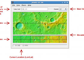
JMARS for Windows3.1.5 by Arizona State University |

|
Software Description:
... roughness data with thermal inertia data.* Contour maps may be created. * Groups of layers can be composed by transparency blending or building an HSV/RGB composite. * Plots may be created by drawing multi-segment lines on the map, making it easy to sample elevation, thermal inertia, or other surface properties in an area of interest. * Load and process raw numeric rasters, which may be stretched and colorized on the fly. * Load and ...
type: Freeware
Download JMARS for Windowscategories: mission analysis, geospatial information, GIS analysis, mission, analysis, GIS Add to Download Basket Report virus or spyware |
 [ Zoom screenshot ] |
|
| Software Info | |
|
Best Vista Download periodically updates pricing and software information of JMARS for Windows full version from the publisher,
but some information may be out-of-date. You should confirm all information. Software piracy is theft, using crack, warez passwords, patches, serial numbers, registration codes, key generator, keymaker or keygen for JMARS for Windows license key is illegal and prevent future development of JMARS for Windows. Download links are directly from our mirrors or publisher's website, JMARS for Windows torrent files or shared files from rapidshare, yousendit or megaupload are not allowed! |
|
| Released: | August 12, 2014 |
| Filesize: | 50.00 MB |
| Platform: | Windows Vista, Windows Vista x64, Windows 7, Windows 7 x64 |
| Install | Instal And Uninstall |
| Add Your Review or Windows Vista Compatibility Report |
JMARS for Windows- Releases History |
| Software: | JMARS for Windows 3.1.5 |
| Date Released: | Aug 12, 2014 |
| Status: | New Release |
| Release Notes: | - In JMARS, locate the "Options" tab at the top of the screen, click it - Click "Check for Updates" |
| Software: | JMARS for Windows 3.0.4 |
| Date Released: | Jun 7, 2013 |
| Status: | New Release |
| Release Notes: | - minor change that will allow users to use Body->reset layers to reset layers to JMARS default/startup state - minor bug fix in the interaction of the Main view and Panner views - accuracy of crater layer settings improved when saving crater layers as part of a saved session - more graceful error handling when loading a saved session - removed the ESRI option from the list for loading/saving in the shape layer. The Geo tools ESRI option is the replacement - a fix for a drawing issue in the TES layer on Mac OS X running Java 7 - lower right corner coordinates added to the high resolution export tool including new UI functionality for setting export height and width - update to how image corners (lat/lon) are specified in high resolution export - added CSV export and look and feel changes to the Investigate tool - improved communication between the Stamp Layer and backend databases - Add Layer UI look and feel improvements - ease of use changes to crater counting layer for small bodies |
Most popular contour in CAD downloads for Vista |
|
TNTmips 20240404 download by MicroImages, Inc.
... from 3D information. Fast and efficient Surface Fitting, Contouring, and Triangulation operations produce Digital Elevation Model rasters (DEMs), contour lines, and triangulated irregular networks (TINs), respectively ... ...
type: Freeware
View Details
Download
categories: GIS data analysis, analyze geodetic data, edit GIS dataset, GIS, dataset, editor, analysis |
 |
|
OutlineArt 1.9.2 download by DWG TOOL Software
... ratio(DXF only) . Setting up smoothness of vector contour . Saving inputted words to txt file for future use . Saving to DXF file . Easy in use. ...
type: Shareware ($29.95)
View Details
Download
categories: ttf to dxf, vector, symbol, dxf, convert, font, cad text editor, cad, arx |
 |
|
Multiwfn 3.7 download by sobereva
... plotting graph. Supported graph types including filled-color map, contour map, relief map (with/without projection), gradient map, vector field map. · Outputting properties in a spatial scope, data can be exported ...
type: Open Source
View Details
Download
categories: wavefunction analysis, topology analysis, molecular structure, analysis, analize, wavefunction |
 |
|
TRIANGULATION for IntelliCAD 3.9d download by Rcad Software
... 3DINTERSECTION, cross sections and a longitudinal profile, color-filled contour map; 7 functions for IntelliCAD versions which can ... may contain arcs. You can also make color-filled contour map. The price is for the first license! ...
type: Shareware ($29.00)
View Details
Download
categories: TRIANGULATION, ISOLINES, VOLUME, INTERSECTION, XYZ points files, IntelliCAD, TOPOGRAPHY, Software, SHAREWARE, XYZ POINTS, CROSS SECTIONS, LONGITUDINAL PROFILES, Surveying, CAD, DXF |
 |
|
RTOPO Hydrology 3.4 download by Rcad Software
... for surveying. You can do triangulation, isolines, color-filled contour maps, sections, intersections, volume and much more. You ... on a convex hull or between an external contour and possibly more interior contours -contour lines and ...
type: Shareware ($125.00)
View Details
Download
categories: CAD for Topography, XYZ File editor, hydrology, LandXML, Triangulation, Isolines, Cross sections, Longitudinal profile, Intersection of two triangulations, quartic triangular patches |
 |
|
3DField 4.1.3 download by Vladimir Galouchko
3DField is a contouring plotting and 3D data program. It converts your data into contour maps, surface or volume plots. 3DField allows create the contours (isolines) on surface from regular data set or ...
View Details
Download
|
 |
|
Topography in AutoCAD 2.3 download by Rcad Software
... at projection. The POLYLINE may contain arcs. Color-filled contour maps can be also generated. In addition, you can draw a DWG file in Google Earth, by generating a 2D or ...
type: Shareware ($59.00)
View Details
Download
categories: AutoCAD Add-ons, Topography, KML creator, KML 3D, XYZ File, LandXML, Triangulation, Isolines, Color-filled contour map, Sections, Volume, surface flatness, BricsCAD add |
 |
|
TopoLT 15.2 download by CADWARE Engineering
... digital format, who develop 3D terrain models and contours, fill and cut volumes calculation, raster image georeferencing ... points; · 3D model of the terrain and contour lines can be generated, volumes can be calculated ...
type: Trialware ($600.00)
View Details
Download
categories: topographical plan, cadastral plan, terrain model, topography, cadaster, terrain |
 |
|
CurveExpert Professional 2.7.3 download by Daniel G. Hyams
... the purposes of 3D plotting, scatterplots, surfaces, and contour plots are supported. Graph themes allow you to customize a look that you prefer, and reuse it. Graphs are interactive, with ...
View Details
Download
|
 |
|
TARGET 3001 20.6.0.58 download by Ing.-Buero FRIEDRICH
... 3001! itself consists of schematic, mixed mode simulation, contour autorouter, autoplacer, PCB layout, 3D view with a STEP export, basic EMC check and a frontpanel layout. It provides manufacturing data ...
type: Trialware ($59.00)
View Details
Download
categories: Mode Simulation, Shape Based, PCB Layout, CAD, shape, Simulation |
 |