Related Keywords
geographic downloadsgeographic information system downloads
geographic marketi downloads
geographic targeting downloads
geographic information systems downloads
geographic coordinate system downloads
geographic coordinates downloads
geographic quiz downloads
geographic area downloads
geographic information downloads
geographic software downloads
geographic data viewer downloads
geographic data downloads
geographic database object downloads
national geographic ghost city downloads
national geographic downloads
analyze geographic information downloads
x64 geographic downloads
convert geographic coordinate downloads
import geographic coordinate downloads
Top Software Keywords
odbc downloadsdatabase downloads
excel downloads
sql downloads
table downloads
mysql downloads
gui downloads
data downloads
export downloads
access downloads
dbf downloads
tool downloads
oracle downloads
convert downloads
csv downloads
server downloads
microsoft downloads
query downloads
conversion downloads
import downloads
sql server downloads
development downloads
utility downloads
management downloads
vista transformation downloads
dictionary downloads
tables downloads
migrate downloads
ems downloads
sqlmanager downloads
Vista Download
Vista downloadVista antivirus download
Vista wallpaper download
Vista wallpapers download
Vista themes download
Vista pack download
Vista ultimate download
Vista home download
Vista basic download
Vista business download
Vista x64 download
Vista transformation download
Vista transformation pack download
Vista boot download
Vista dvd download
Vista sidebar download
Vista aero download
Vista product key download
Downloads RSS
Top Downloads
Top Rated
Navigation: Home
\ Business
\ Databases & Tools \ TOPOWIN
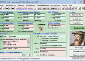
TOPOWIN20.01 by Killet GeoSoftware Ing.-GbR |

|
Software Description:
... program TOPOWIN calculates with Gauss Krueger coordinates and Geographic Coordinates refering to the Potsdam Datum (Bessel ellipsoid with central point Rauenberg). It also works with UTM coordinates and UTMRef coordinates in the NATO standard, which refer to the datum ETRS89 (GRS80 / WGS84, geocentric). ...
type: Shareware ($125.00)
Download TOPOWINcategories: topography, geodetics, geography, corner, box, coordinate, map, guide, TK25, TK50, TK50, TK100, TKUE200, GK5, DGK5, geosoftware, registers, place, topowin, topo, placelist, information, system, measuring Add to Download Basket Report virus or spyware |
 [ Zoom screenshot ] |
|
| Software Info | |
|
Best Vista Download periodically updates pricing and software information of TOPOWIN full version from the publisher,
but some information may be out-of-date. You should confirm all information. Software piracy is theft, using crack, warez passwords, patches, serial numbers, registration codes, key generator, keymaker or keygen for TOPOWIN license key is illegal and prevent future development of TOPOWIN. Download links are directly from our mirrors or publisher's website, TOPOWIN torrent files or shared files from rapidshare, yousendit or megaupload are not allowed! |
|
| Released: | June 20, 2021 |
| Filesize: | 4.52 MB |
| Language: | English, German |
| Platform: | Win2000, Windows XP, Windows 7 x32, Windows 7 x64, Windows 8, Windows 10, WinServer, WinOther, Windows Vista, Windows Vista x64 |
| Requirements: | Pentium, 50 MB HD |
| Install | Install and Uninstall |
| Add Your Review or Windows Vista Compatibility Report |
TOPOWIN- Releases History |
| Software: | TOPOWIN 20.01 |
| Date Released: | Jun 20, 2021 |
| Status: | Major Update |
| Release Notes: | Program is faster and more stable using a new development system. All databases actualized on 1st. January 2021. Territorial Reform in Thuringia of the year 2019 implemented. View of maps in OpenTopoMap, Google Maps, Google Earth. All map views supplemented with UTM edge coordinates. |
| Software: | TOPOWIN 15.01 |
| Date Released: | Feb 23, 2016 |
| Status: | Major Update |
| Release Notes: | All databases actualized on 1st. January 2016. WINDOWS©10 certification after 32Bit / 64Bit intensive test. 8100 new town quarters added. 34600 location coordinates changed with higher accuracy. Output of window contents in GIF and BMP files. |
| Software: | TOPOWIN 15.00 |
| Date Released: | Jan 25, 2016 |
| Status: | Major Update |
| Release Notes: | WINDOWS©10 certification after 32Bit / 64Bit intensive test. All databases actualized on 1st. January 2015. 8100 new town quarters added. 34600 location coordinates changed with higher accuracy. Output of window contents in GIF and BMP files. |
Most popular geographic in Databases & Tools downloads for Vista |
|
DBF Viewer 2000 7.59 download by HiBase Group
... of applications, from simple data management tools to geographic information systems. If you are a database developer or deal with DBF databases on a regular basis, you know very well ...
type: Shareware ($49.95)
View Details
Download
categories: dbf editor, dbf file, dbf files, foxpro editor, dbase editor, dbase, dbase file, foxpro table |
 |
|
ORTWIN 17.03 download by Killet GeoSoftware Ing.-GbR
... the Potsdam Datum (Bessel ellipsoid, Rauenberg) and with Geographic Coordinates on the geodetic datum WGS84. It also works with UTM coordinates, which refer to the datum ETRS89 (GRS80, geocentric). The ...
type: Shareware ($125.00)
View Details
Download
categories: local, index, register, place, locality, town, city, cities, quarter, geo, coding, periphery, perimeter, search, distance, municipality, district, coordinate, coordinates, elevation, longitude, latitude, snow load, wind load, landscape, center, distance, transformation |
 |
|
TOPOWIN 20.01 download by Killet GeoSoftware Ing.-GbR
... program TOPOWIN calculates with Gauss Krueger coordinates and Geographic Coordinates refering to the Potsdam Datum (Bessel ellipsoid with central point Rauenberg). It also works with UTM coordinates and UTMRef coordinates ...
type: Shareware ($125.00)
View Details
Download
categories: topography, geodetics, geography, corner, box, coordinate, map, guide, TK25, TK50, TK50, TK100, TKUE200, GK5, DGK5, geosoftware, registers, place, topowin, topo, placelist, information, system, measuring |
 |
|
Geodata International 13.03 download by Killet GeoSoftware Ing.-GbR
... natural and an uniformly meridian strip and as geographical coordinates in degree and deg/min/sec notation. With the elevation data from a Digital Elevation Model the ground level height of each ...
type: Data Only ($165.00)
View Details
Download
categories: geo, data, geodata, point, pointdata, spatial, reference, coding, coordinates, places, local, localities, town, quarters, postal, zip, code, periphery, search, distance, calculation, elevation, list, listing, municipality, database, longitude, latitude, geographic, utm, wgs84 |
 |
|
TOPOWIN 23.02 download by Killet GeoSoftware Ing.-GbR
... program TOPOWIN calculates with Gauss Krueger coordinates and Geographic Coordinates refering to the Potsdam Datum (Bessel ellipsoid with central point Rauenberg). It also works with UTM coordinates and UTMRef coordinates ...
type: Shareware ($125.00)
View Details
Download
categories: topography, geodetics, geography, corner, box, coordinate, map, guide, TK25, TK50, TK50, TK100, TKUE200, GK5, DGK5, geosoftware, registers, place, topowin, topo, placelist, information, system, measuring |
 |
|
ORTWIN 20.02 download by Killet GeoSoftware Ing.-GbR
... the Potsdam Datum (Bessel ellipsoid, Rauenberg) and with Geographic Coordinates on the geodetic datum WGS84. It also works with UTM coordinates, which refer to the datum ETRS89 (GRS80, geocentric). The ...
type: Shareware ($120.00)
View Details
Download
categories: local, index, register, place, locality, town, city, cities, quarter, geo, coding, periphery, perimeter, search, distance, municipality, district, coordinate, coordinates, elevation, longitude, latitude, snow load, wind load, landscape, center, distance, transformation |
 |