Related Keywords
maps downloadsmaps flash downloads
maps in flash downloads
maps for website downloads
maps puzzle downloads
maps icon downloads
maps icons downloads
maps x64 downloads
maps downloader downloads
image maps downloads
interactive maps downloads
flash maps downloads
business maps downloads
mind maps downloads
concept maps downloads
3d mind maps downloads
interactive flash maps downloads
usa maps downloads
informative maps downloads
thematic maps downloads
Top Software Keywords
photoshop downloadsphoto editing downloads
graphics downloads
picture downloads
image editing downloads
image editor downloads
photos downloads
free photo editor downloads
images downloads
free photo editing software downloads
digital photography downloads
texture downloads
effects downloads
image downloads
graphic downloads
resize downloads
photo editor downloads
gif downloads
editor downloads
photo editing software downloads
digital photo downloads
edit downloads
digital downloads
jpeg downloads
photo downloads
photography downloads
bmp downloads
jpg downloads
watermark downloads
batch downloads
Vista Download
Vista downloadVista antivirus download
Vista wallpaper download
Vista wallpapers download
Vista themes download
Vista pack download
Vista ultimate download
Vista home download
Vista basic download
Vista business download
Vista x64 download
Vista transformation download
Vista transformation pack download
Vista boot download
Vista dvd download
Vista sidebar download
Vista aero download
Vista product key download
Downloads RSS
Featured Download

PicaJet FX
Digital photo
management software

AKVIS Enhancer
Photo Enhancement
Software
Top Downloads
Top Rated
Navigation: Home
\ Graphic Apps
\ Editors \ RoboGEO
RoboGEO6.3.2 by Pretek, Inc. |

|
Software Description:
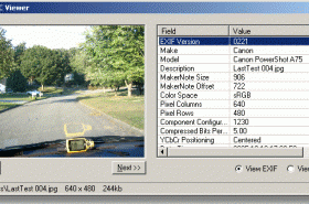
Geotag digital images with latitude, longitude, altitude, and direction information. RoboGEO stamps this information onto the actual photo or writes it to the EXIF headers. In addition, RoboGEO allows you to permanently geotag and link your photos to the GPS coordinates.All writing to the EXIF and IPTC headers is lossless and all of the existing comments (including the MakerNote and the Adobe XMP metadata) are preserved. Includes a Picasa-style geotagger for Google Earth. ...
type: Demo ($79.95)
Download RoboGEOcategories: georeference image, Geographical Information System, geotag EXIF photo, geotag, reference, geocode Add to Download Basket Report virus or spyware |
 [ Zoom screenshot ] |
|
| Software Info | |
|
Best Vista Download periodically updates pricing and software information of RoboGEO full version from the publisher,
but some information may be out-of-date. You should confirm all information. Software piracy is theft, using crack, warez passwords, patches, serial numbers, registration codes, key generator, keymaker or keygen for RoboGEO license key is illegal and prevent future development of RoboGEO. Download links are directly from our mirrors or publisher's website, RoboGEO torrent files or shared files from rapidshare, yousendit or megaupload are not allowed! |
|
| Released: | February 27, 2012 |
| Filesize: | 13.40 MB |
| Platform: | Windows XP, Windows Vista, Windows Vista x64, Windows 7, Windows 7 x64, Windows 8, Windows 8 x64, Windows 10, Windows 10 x64 |
| Install | Instal And Uninstall |
| Add Your Review or Windows Vista Compatibility Report |
RoboGEO- Releases History |
| Software: | RoboGEO 6.3.2 |
| Date Released: | Feb 27, 2012 |
| Status: | New Release |
| Release Notes: | · Added Google Earth polygon file support and the ability to export HTML |
| Software: | RoboGEO 6.3.1 |
| Date Released: | Jan 3, 2012 |
| Status: | New Release |
| Release Notes: | · Added Google Earth polygon file support and the ability to export HTML |
| Software: | RoboGEO 6.3.0 |
| Date Released: | Oct 11, 2011 |
| Status: | New Release |
| Release Notes: | · Added Google Earth polygon file support and the ability to export HTML |
Most popular maps in Editors downloads for Vista |
|
Airphoto 3.58 download by Irwin Scollar
... orthophotos from scanned extreme obliques and superimposes scanned maps on them in various ways. It is not ... obtained directly from a scanner. Any number of maps may be combined to obtain a result for ...
View Details
Download
|
 |
|
Vextractor 7.20 download by VextraSoft
... Design software. You can also vectorize charts, drawings, maps and schemes for input to CAD or GIS systems. Main features of Vextractor: Input raster formats: BMP, GIF, TIFF, GeoTIFF, JPEG, ...
type: Shareware ($99.95)
View Details
Download
categories: raster to vector, image to vector, raster, vector, vectorise, vectorize, vectorization, vectorizing, trace, convert, conversion, r2v, scan, cad, autocad, dxf, tiff, gif, bmp.jpg, jpeg, polyline, centerline, outline, image, gis, digitize, digitizing |
 |
|
RoboGEO 6.3.2 download by Pretek, Inc.
Geotag digital images with latitude, longitude, altitude, and direction information. RoboGEO stamps this information onto the actual photo or writes it to the EXIF headers. In addition, RoboGEO allows you to ...
type: Demo ($79.95)
View Details
Download
categories: georeference image, Geographical Information System, geotag EXIF photo, geotag, reference, geocode |
 |
|
Image Constructor 2.5 download by Image Tools Group
... original illustrations, structural schemas and diagrams, simple geographical maps and location plants in form of texts and small images over some background with picture or gradient fill and save them ...
type: Shareware ($25.00)
View Details
Download
categories: imageconstructor, image, constructor, create illustration, presentation, picture, geographical map, plan, graphics, webgraphics, flowchart, diagram, schema, image collection, GIF, publishing, homepage, imageediting, web, business, software, downloads |
 |
|
3DFieldPro 4.5.9.1 download by Vladimir Galouchko
... data program. It converts your data into contour maps, surface or volume plots. 3DFieldPro allows to create ... scattered points. All aspects of 2D or 3D maps can be customized to produce exactly the presentation ...
View Details
Download
|
 |
|
Displacement Map 1.0 download by ImageSkill Software
... plug-in is supplied with a set of displacement maps. It is very useful for artistic image processing. The Displacement Map has a stylish, user-friendly, intuitive, multi-lingual interface. A user can ...
type: Freeware
View Details
Download
categories: image distortion, warping, bending, geometric displacement, bump mapping, displacement map, displacement mapping, displacement map, ImageSkil, plugin, plug-ins, photo |
 |
|
Dr. Regener LandMap Vivo 10 download by GPSsur Dr. Erhard Regener
Create own true to scale maps, store online maps locally with Vivo techology, map editor, dataexchange with ...
type: Shareware ($65.00)
View Details
Download
categories: Map, geodata, wgs84, aereal photo, orthophoto, GPS, openstreetmap, google earth, virtual earth, roadmap, landmap, satellite, kml, kmz, onlinemaps, GPX |
 |
|
Panorama Express Professional 3.0 download by Imatronics
... virtual tour navigation controls * multiple synchronized interactive maps * multiple synchronized interactive compasses * multiple independent interactive maps * multiple hotspots of different kinds * multiple ...
type: Trialware ($99.00)
View Details
Download
categories: create tour, create interactive panorama, panoramic tours, creator, editor, viewer |
 |
|
PhotoPlus SE 1.0.0.11 download by Serif Ltd.
... Furthermore the program lets you create HTML image maps and also slice images into multiple parts using the visual slicing tool. Additional filters and plug-ns can be downloaded as free ...
View Details
Download
|
 |
|
PhotoLine 22.01 download by Computerinsel
... Export * Tile images, create buttons and image maps Many more * Batch conversion * Create slideshows * Record actions * Print multipage documents, flyers and labels * ...
View Details
Download
|
 |