Related Keywords
add image downloadsadd image watermark downloads
add image shadow downloads
add image to video downloads
add image to subtilte downloads
add image to pdf file downloads
add image layer downloads
image into nude image downloads
image cut (image splitter) downloads
image within an image downloads
image cut image splitter downloads
image resize photos change size image resizer downloads
add report downloads
add-in downloads
add downloads
add remove downloads
add-on downloads
add/remove downloads
add-ins downloads
add frames downloads
Top Software Keywords
autocad downloadscad downloads
3d cad downloads
drawing downloads
import downloads
design downloads
dwg downloads
dxf downloads
pdf to dwg downloads
convert downloads
convert pdf to dwg downloads
dwg to pdf downloads
converter downloads
dxf to pdf downloads
dwg to dxf downloads
pdf to dxf downloads
dwf to dwg downloads
dwg converter downloads
dwg to jpg downloads
dwg to bmp downloads
stl downloads
dxf to pcl downloads
dwg to tiff downloads
intellicad downloads
pdf to cad downloads
dwg to gif downloads
convert dwg to pdf downloads
dwg to png downloads
dwg to dwf downloads
dxf to ps downloads
Vista Download
Vista downloadVista antivirus download
Vista wallpaper download
Vista wallpapers download
Vista themes download
Vista pack download
Vista ultimate download
Vista home download
Vista basic download
Vista business download
Vista x64 download
Vista transformation download
Vista transformation pack download
Vista boot download
Vista dvd download
Vista sidebar download
Vista aero download
Vista product key download
Downloads RSS
Top Downloads
Top Rated
Navigation: Home
\ Graphic Apps
\ CAD \ TNTmips
TNTmips20240404 by MicroImages, Inc. |

|
Software Description:
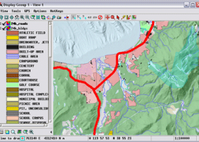
TNTmips is a geospatial image processing tool that allows you to analyze and modify GIS images. It is a professional application that can handle desktop cartography, electronic atlas preparation and spatial database management. ...
type: Freeware
Download TNTmipscategories: GIS data analysis, analyze geodetic data, edit GIS dataset, GIS, dataset, editor, analysis Add to Download Basket Report virus or spyware |
 [ Zoom screenshot ] |
|
| Software Info | |
|
Best Vista Download periodically updates pricing and software information of TNTmips full version from the publisher,
but some information may be out-of-date. You should confirm all information. Software piracy is theft, using crack, warez passwords, patches, serial numbers, registration codes, key generator, keymaker or keygen for TNTmips license key is illegal and prevent future development of TNTmips. Download links are directly from our mirrors or publisher's website, TNTmips torrent files or shared files from rapidshare, yousendit or megaupload are not allowed! |
|
| Released: | April 04, 2024 |
| Filesize: | 121.00 MB |
| Platform: | Windows XP, Windows Vista, Windows Vista x64, Windows 7, Windows 7 x64, Windows 8, Windows 8 x64, Windows 10, Windows 10 x64, Windows 11 |
| Install | Instal And Uninstall |
| Add Your Review or Windows Vista Compatibility Report |
TNTmips- Releases History |
| Software: | TNTmips 20240404 |
| Date Released: | Apr 4, 2024 |
| Status: | New Release |
| Software: | TNTmips 20240131 |
| Date Released: | Jan 31, 2024 |
| Status: | New Release |
| Software: | TNTmips 20240108 |
| Date Released: | Jan 8, 2024 |
| Status: | New Release |
Most popular add image in CAD downloads for Vista |
|
myHouse 9.0.112 download by DesignSoft
... color 3D and use myHouse's DreamScapeTM feature to add background to your design from any .BMP image. With the State of the Art 3D ... of myHouse you can create virtual reality panoramic images that can be explored interactively both on your ...
type: Trialware ($39.95)
View Details
Download
categories: create house project, house designer, construction simulator, create, design, designer |
 |
|
Elshayal Smart 23.02 download by Elshayal Smart Web On Line Software
... save GPS route and View and Rectify Raster Images gif, jpg, bmp and Edit shape files, build new layer, add existing layer, remove layers, swap layers, save layer, ... network, find shortest path, print map, save map image, copy map image to clipboard, save project map, ...
View Details
Download
|
 |
|
TNTmips 20240404 download by MicroImages, Inc.
... with virtually any type of geospatial data including imagery, terrain surfaces, and map data with associated database ... single package at an affordable price without costly add-ons. Precisely overlay geodata layers in a variety ...
type: Freeware
View Details
Download
categories: GIS data analysis, analyze geodetic data, edit GIS dataset, GIS, dataset, editor, analysis |
 |
|
HighDesign 2023.1.1.2184.0 download by ILEXSOFT
... to manage an entire project in one document. Add named views, styles and building element types, custom ... scaled and perspective-correct elevations from a single picture; image editing functions; a drawing presentation tool to generate ...
type: Shareware ($449.00)
View Details
Download
categories: CAD, BIM, drafting, drawing, project, architecture, engineering, construction, mechanical, dxf, dwg, pdf, vector, design, autocad, plans, remodel, floorplan, blueprint, draught, layout, technical, sketch |
 |
|
PlanEasy2D 1.11 download by PlanAndVisualize
... of each room or floor. Simply click and add furnitures. Easy to move, resize or rotate the ... color of the room with a simple click. Add text ,format it or even move, resize and ...
View Details
Download
|
 |
|
GPS Utility 5.51 download by GPS Utility Ltd.
... plot your GPS information as a map and add map annotations in text or image form. GPS Utility can also be set ...
type: Demo ($60.00)
View Details
Download
categories: Waypoint Manager, GPS Receiver, Digitise GPS, Waypoint, GPD, Digitise |
 |
|
Gerbview x64 10.21 download by Software Companions
... relative coordinates. Highlight selected apertures in Gerber files. Add files of different formats to a single workspace. ... CALS, Adobe PDF, Windows BMP, PNG and JPEG. Add markup using lines, text, rectangles, images, QR-codes, barcodes, ...
type: Trialware ($80.00)
View Details
Download
categories: x64 print Gerber image, view plot x64, convert Gerber x64, convert x64, Gerber x64, print x64 |
 |
|
CADbro 2020 download by ZWSOFT CO., LTD.(Guangzhou)
... if required. Vivid 3D Annotation You can easily add dimensions, tolerance, symbols, or texts directly on the ... Feature Control Symbol, Surface Finish Symbol Label, Text, Image Balloon Advanced Analysis With diversified query & analysis ...
type: Shareware ($1 500.00)
View Details
Download
categories: CAD viewer, Cloud, 3D CAD viewer, 3D viewer, 3D converter, CAD converter, 3D translator, CAD translator, Catia viewer, Solidworks viewer, DWG viewer, DXF viewer, Creo viewer, PTC viewer, UG viewer, STL viewer, Step viewer, DWG converter, DXF converte |
 |
|
Panoply 5.4.3 download by Robert B. Schmunk
... whose purpose is to help you plot raster images. It lets you view photos created with NetCDF, ... button or drag-and-drop support. You are allowed to add data from one of the datasets mentioned at ...
type: Freeware
View Details
Download
categories: plot raster image, longitude image, pole-to-pole image, raster image, rasterize, raster |
 |
|
Sweet Home 3D 7.4 download by Sweethome3d
... draw the walls of your home upon the image of an existing plan, change the color or ... along with the 3D view, create a photorealistic image of the 3D view, and export the plan ...
type: Open Source
View Details
Download
categories: interior design, interior design software, placing your furniture, free interior design software, 2D plan, 3D plan, 3D preview, free interior design, SweetHome 3D |
 |