Related Keywords
coordinates downloadscoordinates conversion downloads
coordinates conversions downloads
view all coordinates downloads
spherical coordinates downloads
geo coordinates downloads
house coordinates downloads
convert coordinates downloads
geographic coordinates downloads
gps coordinates conversion downloads
multiple coordinates downloads
lat long coordinates downloads
list of coordinates downloads
add gps coordinates downloads
sea battle by coordinates downloads
Top Software Keywords
odbc downloadsdatabase downloads
excel downloads
table downloads
sql downloads
mysql downloads
data downloads
gui downloads
export downloads
access downloads
dbf downloads
tool downloads
oracle downloads
convert downloads
csv downloads
server downloads
microsoft downloads
query downloads
conversion downloads
import downloads
sql server downloads
development downloads
utility downloads
management downloads
vista transformation downloads
dictionary downloads
tables downloads
migrate downloads
ems downloads
sqlmanager downloads
Vista Download
Vista downloadVista antivirus download
Vista wallpaper download
Vista wallpapers download
Vista themes download
Vista pack download
Vista ultimate download
Vista home download
Vista basic download
Vista business download
Vista x64 download
Vista transformation download
Vista transformation pack download
Vista boot download
Vista dvd download
Vista sidebar download
Vista aero download
Vista product key download
Downloads RSS
Top Downloads
Top Rated
Navigation: Home
\ Business
\ Databases & Tools \ ORTWIN
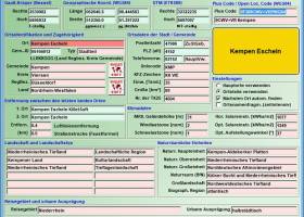
ORTWIN20.02 by Killet GeoSoftware Ing.-GbR |

|
Software Description:
... It finds postal zip codes, telephone pre selections, coordinates and ground level elevations. The program determines municipal ... between the places. It calculates with Gauss Krueger coordinates referring to the Potsdam Datum (Bessel ellipsoid, Rauenberg) and with Geographic Coordinates on the geodetic datum WGS84. It also works with UTM coordinates, which refer to the datum ETRS89 (GRS80, geocentric). The functionality of the program is described in a detailed electronic manual. ...
type: Shareware ($120.00)
Download ORTWINcategories: local, index, register, place, locality, town, city, cities, quarter, geo, coding, periphery, perimeter, search, distance, municipality, district, coordinate, coordinates, elevation, longitude, latitude, snow load, wind load, landscape, center, distance, transformation Add to Download Basket Report virus or spyware |
 [ Zoom screenshot ] |
|
| Software Info | |
|
Best Vista Download periodically updates pricing and software information of ORTWIN full version from the publisher,
but some information may be out-of-date. You should confirm all information. Software piracy is theft, using crack, warez passwords, patches, serial numbers, registration codes, key generator, keymaker or keygen for ORTWIN license key is illegal and prevent future development of ORTWIN. Download links are directly from our mirrors or publisher's website, ORTWIN torrent files or shared files from rapidshare, yousendit or megaupload are not allowed! |
|
| Released: | March 06, 2024 |
| Filesize: | 4.86 MB |
| Language: | English, German |
| Platform: | Win2000, Windows XP, Windows 7 x32, Windows 7 x64, Windows 8, Windows 10, WinServer, WinOther, Windows 2000, Windows 2003, Windows Server 2000, Windows Server 2003, Windows Server 2008, Windows Server 2008r2, Windows Server 2012, Windows Tablet PC Edition 2005, Windows Media Center Edition 2005, Windows Vista, Windows Vista x64 |
| Requirements: | Pentium, 50 MB HD |
| Install | Install and Uninstall |
| Add Your Review or Windows Vista Compatibility Report |
ORTWIN- Releases History |
| Software: | ORTWIN 20.02 |
| Date Released: | Mar 6, 2024 |
| Status: | Major Update |
| Release Notes: | All data applied updated to the data status January 1, 2024. New data Sunshine Duration and Precipitation Amount. New data Solar Irradiance in W/m2 and Regional Key. View of localities in OpenStreetMap, Google Maps, Google Earth. Determining the wind load zones and snow load zones. |
| Software: | ORTWIN 20.00 |
| Date Released: | Jan 1, 2024 |
| Status: | Major Update |
| Release Notes: | All data applied updated to the data status January 1, 2023. New data Sunshine Duration and Precipitation Amount. New data Solar Irradiance in W/m2 and Regional Key. View of localities in OpenStreetMap, Google Maps, Google Earth. Determining the wind load zones and snow load zones. |
| Software: | ORTWIN 19.01 |
| Date Released: | Jul 4, 2023 |
| Status: | Major Update |
| Release Notes: | All data applied updated to the data status January 1, 2023. New data Sunshine Duration and Precipitation Amount. New data Solar Irradiance in W/m2 and Regional Key. View of localities in OpenStreetMap, Google Maps, Google Earth. Determining the wind load zones and snow load zones. |
Most popular coordinates in Databases & Tools downloads for Vista |
|
TOPOWIN 20.01 download by Killet GeoSoftware Ing.-GbR
... available. The program TOPOWIN calculates with Gauss Krueger coordinates and Geographic Coordinates refering to the Potsdam Datum (Bessel ellipsoid with central point Rauenberg). It also works with UTM coordinates and UTMRef coordinates in the NATO standard, which ...
type: Shareware ($125.00)
View Details
Download
categories: topography, geodetics, geography, corner, box, coordinate, map, guide, TK25, TK50, TK50, TK100, TKUE200, GK5, DGK5, geosoftware, registers, place, topowin, topo, placelist, information, system, measuring |
 |
|
Geodata Germany 28.01 download by Killet GeoSoftware Ing.-GbR
... zones and official topographical cartographies. The data contain coordinates for navigation and geo-coding, proximity searches and distance ... or telephone preselection, to corresponding geographical data and coordinates - a Geo Reference. The geo reference can ...
type: Data Only ($175.00)
View Details
Download
categories: geodata, cities, towns, municipalities, postal codes, area codes, coordinates, georeferences, perimeter search, natural area, landscape, snow load, wind load, solar radiation, distance calculation, administrative units |
 |
|
Geodata International 13.03 download by Killet GeoSoftware Ing.-GbR
... codes and administrative units with WGS84 and UTM coordinates and elevations for geocoding, proximity search, navigation, distance ... or postal areas can be determined with the coordinates contained in the database tables. For that the ...
type: Data Only ($165.00)
View Details
Download
categories: geo, data, geodata, point, pointdata, spatial, reference, coding, coordinates, places, local, localities, town, quarters, postal, zip, code, periphery, search, distance, calculation, elevation, list, listing, municipality, database, longitude, latitude, geographic, utm, wgs84 |
 |
|
ORTWIN 17.03 download by Killet GeoSoftware Ing.-GbR
... It finds postal zip codes, telephone pre selections, coordinates and ground level elevations. The program determines municipal ... between the places. It calculates with Gauss Krueger coordinates referring to the Potsdam Datum (Bessel ellipsoid, Rauenberg) ...
type: Shareware ($125.00)
View Details
Download
categories: local, index, register, place, locality, town, city, cities, quarter, geo, coding, periphery, perimeter, search, distance, municipality, district, coordinate, coordinates, elevation, longitude, latitude, snow load, wind load, landscape, center, distance, transformation |
 |
|
TOPOWIN 23.02 download by Killet GeoSoftware Ing.-GbR
... available. The program TOPOWIN calculates with Gauss Krueger coordinates and Geographic Coordinates refering to the Potsdam Datum (Bessel ellipsoid with central point Rauenberg). It also works with UTM coordinates and UTMRef coordinates in the NATO standard, which ...
type: Shareware ($125.00)
View Details
Download
categories: topography, geodetics, geography, corner, box, coordinate, map, guide, TK25, TK50, TK50, TK100, TKUE200, GK5, DGK5, geosoftware, registers, place, topowin, topo, placelist, information, system, measuring |
 |
|
ORTWIN 20.02 download by Killet GeoSoftware Ing.-GbR
... It finds postal zip codes, telephone pre selections, coordinates and ground level elevations. The program determines municipal ... between the places. It calculates with Gauss Krueger coordinates referring to the Potsdam Datum (Bessel ellipsoid, Rauenberg) ...
type: Shareware ($120.00)
View Details
Download
categories: local, index, register, place, locality, town, city, cities, quarter, geo, coding, periphery, perimeter, search, distance, municipality, district, coordinate, coordinates, elevation, longitude, latitude, snow load, wind load, landscape, center, distance, transformation |
 |