Related Keywords
data on map downloadsdata to map downloads
photos on map downloads
wipe data on your disk downloads
record data on cdr autorun downloads
recovering data on memory card downloads
recover data on android downloads
access mac data on windows downloads
restore data on mac quickly downloads
recover lost data on ipod downloads
restore data on android phone downloads
erase data on iphone downloads
erase all data on iphone downloads
recover lost data on iphone downloads
manage data on ios devices downloads
erase data on ios devices downloads
encrypt data on usb drives downloads
data map downloads
map data field downloads
data recovery on pen drive downloads
Top Software Keywords
autocad downloadscad downloads
3d cad downloads
drawing downloads
import downloads
design downloads
dwg downloads
dxf downloads
pdf to dwg downloads
convert downloads
convert pdf to dwg downloads
dwg to pdf downloads
converter downloads
dxf to pdf downloads
dwg to dxf downloads
pdf to dxf downloads
dwf to dwg downloads
dwg converter downloads
dwg to jpg downloads
dwg to bmp downloads
stl downloads
dxf to pcl downloads
dwg to tiff downloads
intellicad downloads
pdf to cad downloads
dwg to gif downloads
convert dwg to pdf downloads
dwg to png downloads
dwg to dwf downloads
dxf to ps downloads
Vista Download
Vista downloadVista antivirus download
Vista wallpaper download
Vista wallpapers download
Vista themes download
Vista pack download
Vista ultimate download
Vista home download
Vista basic download
Vista business download
Vista x64 download
Vista transformation download
Vista transformation pack download
Vista boot download
Vista dvd download
Vista sidebar download
Vista aero download
Vista product key download
Downloads RSS
Top Downloads
Top Rated
Navigation: Home
\ Graphic Apps
\ CAD \ JMARS for Windows
JMARS for Windows3.1.5 by Arizona State University |

|
Software Description:
... Space Flight Facility to provide mission planning and data-analysis tools to NASA's orbiters, instrument team members, students of all ages, and the general public. ...
type: Freeware
Download JMARS for Windowscategories: mission analysis, geospatial information, GIS analysis, mission, analysis, GIS Add to Download Basket Report virus or spyware |
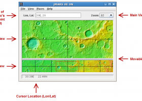 [ Zoom screenshot ] |
|
| Software Info | |
|
Best Vista Download periodically updates pricing and software information of JMARS for Windows full version from the publisher,
but some information may be out-of-date. You should confirm all information. Software piracy is theft, using crack, warez passwords, patches, serial numbers, registration codes, key generator, keymaker or keygen for JMARS for Windows license key is illegal and prevent future development of JMARS for Windows. Download links are directly from our mirrors or publisher's website, JMARS for Windows torrent files or shared files from rapidshare, yousendit or megaupload are not allowed! |
|
| Released: | August 12, 2014 |
| Filesize: | 50.00 MB |
| Platform: | Windows Vista, Windows Vista x64, Windows 7, Windows 7 x64 |
| Install | Instal And Uninstall |
| Add Your Review or Windows Vista Compatibility Report |
JMARS for Windows- Releases History |
| Software: | JMARS for Windows 3.1.5 |
| Date Released: | Aug 12, 2014 |
| Status: | New Release |
| Release Notes: | - In JMARS, locate the "Options" tab at the top of the screen, click it - Click "Check for Updates" |
| Software: | JMARS for Windows 3.0.4 |
| Date Released: | Jun 7, 2013 |
| Status: | New Release |
| Release Notes: | - minor change that will allow users to use Body->reset layers to reset layers to JMARS default/startup state - minor bug fix in the interaction of the Main view and Panner views - accuracy of crater layer settings improved when saving crater layers as part of a saved session - more graceful error handling when loading a saved session - removed the ESRI option from the list for loading/saving in the shape layer. The Geo tools ESRI option is the replacement - a fix for a drawing issue in the TES layer on Mac OS X running Java 7 - lower right corner coordinates added to the high resolution export tool including new UI functionality for setting export height and width - update to how image corners (lat/lon) are specified in high resolution export - added CSV export and look and feel changes to the Investigate tool - improved communication between the Stamp Layer and backend databases - Add Layer UI look and feel improvements - ease of use changes to crater counting layer for small bodies |
Most popular data on map in CAD downloads for Vista |
|
Elshayal Smart 23.02 download by Elshayal Smart Web On Line Software
... remove layers, swap layers, save layer, set layer data source, layer properties, zoom in & zoom out, pan, identify, selecting features, invert selection, show data table, data query builder, location query builder, build ...
View Details
Download
|
 |
|
GPS Utility 5.51 download by GPS Utility Ltd.
... GPS information. You can use it to transfer data to/from a GPS receiver and store the data in PC files in one of several text formats. The program converts between different map datums and many coordinate formats (Lat/Long, UTM/UPS, country ...
type: Demo ($60.00)
View Details
Download
categories: Waypoint Manager, GPS Receiver, Digitise GPS, Waypoint, GPD, Digitise |
 |
|
TNTmips 20240404 download by MicroImages, Inc.
... you work with virtually any type of geospatial data including imagery, terrain surfaces, and map data with associated database attributes. It provides all the tools you need ... georeference, interpret, and publish any type of geospatial data. TNTmips provides professional geospatial tools in a single ...
type: Freeware
View Details
Download
categories: GIS data analysis, analyze geodetic data, edit GIS dataset, GIS, dataset, editor, analysis |
 |
|
ExpertGPS 8.64 download by TopoGrafix
... you can draw your route directly on a map, search for nearby features from the millions of waypoints available in our database, and transfer your trip directly to your GPS ... out on a trip, and all of your data is available. ExpertGPS keeps track of which ...
View Details
Download
|
 |
|
Thuban for Windows 1.2.2 download by Thuban Development Team
Thuban is an interactive geographic data viewer (GIS viewer) which features methods to visualize, ... geographic information. Thuban is an Interactive Geographic Data Viewer with the following features: # Vector ...
type: Open Source
View Details
Download
categories: geographic data viewer, gis viewer, analyze geographic information, information, geographic, viewer |
 |
|
Engauge Digitizer for Windows 12.0 download by Mark Mitchell
... converts an image file showing a graph or map, into numbers. The image file can come from ... with an image file containing a graph or map. The final result is digitized data that can ...
type: Open Source
View Details
Download
categories: digitize image, image to number, process image, digitize, convert, digitizer |
 |
|
SoundStepper 5.4.1.304 download by Maciel
... telescope control, such as for example a sky map, autoguiding, or capture images from a webcam or ... to use the computer's sound hardware, which has data buffers and processing itself, to control step motors ...
type: Open Source
View Details
Download
categories: telescope controller, control telescope, telescope mount, controller, control, telescope |
 |
|
Terra Excess 25.1217 download by Terra Excess Software
... Excess can generate contour lines from topographic survey data in a very simple way. All you need ... Generated contours can be used as a base map for designing and implementing various construction projects or ...
type: Shareware ($298.00)
View Details
Download
categories: land surveying, civil engineering, topographic, contour lines, contour map, triangulated irregular network, earthworks, volumetric, volume calculation, cut and fill, volumes, estimating volumes, survey points, CAD, DXF, quarries, tin surface |
 |
|
TransLT 15.0 download by 3D Space
... contains a module that extracts information from EPSG database. TransLT is aimed at specialists who use GPS ... program interface is intuitive, easy to use, the data can be imported from txt or csv files, ...
type: Trialware ($250.00)
View Details
Download
categories: calculate transformation parameter, coordinate transformation, transformation parameter, calculate, geodetic, GPS |
 |
|
CueMol 2.2.3.442 download by BKR Laboratory
... (CCP4, CNS , and BRIX format), MSMS surface data, and GRASP electrostatic potential map. ...
type: Freeware
View Details
Download
categories: view macromolecular structure, macromolecular structure visualization, visualize macromolecular structure, viewer, view, visualize |
 |