Related Keywords
digital downloadsdigital camera downloads
digital photo downloads
digital photos downloads
digital photography downloads
digital photo software downloads
digital imaging downloads
digital publishing downloads
digital web book downloads
digital photo recovery downloads
digital image recovery downloads
digital image downloads
digital signature downloads
digital sign downloads
digital photo frame downloads
digital picture frame downloads
digital video downloads
digital photo printing downloads
digital picture recovery downloads
digital audio recorder downloads
Top Software Keywords
autocad downloadscad downloads
3d cad downloads
drawing downloads
import downloads
design downloads
dwg downloads
pdf to dwg downloads
dxf downloads
convert downloads
convert pdf to dwg downloads
dwg to pdf downloads
converter downloads
dxf to pdf downloads
dwg to dxf downloads
pdf to dxf downloads
dwf to dwg downloads
dwg to jpg downloads
dwg converter downloads
dwg to bmp downloads
stl downloads
dxf to pcl downloads
dwg to tiff downloads
intellicad downloads
pdf to cad downloads
dwg to gif downloads
convert dwg to pdf downloads
dwg to png downloads
dwg to dwf downloads
dxf to ps downloads
Vista Download
Vista downloadVista antivirus download
Vista wallpaper download
Vista wallpapers download
Vista themes download
Vista pack download
Vista ultimate download
Vista home download
Vista basic download
Vista business download
Vista x64 download
Vista transformation download
Vista transformation pack download
Vista boot download
Vista dvd download
Vista sidebar download
Vista aero download
Vista product key download
Downloads RSS
Top Downloads
Top Rated
Navigation: Home
\ Graphic Apps
\ CAD \ TopoLT
TopoLT15.2 by CADWARE Engineering |

|
Software Description:
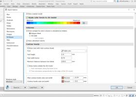
... those who design topographical or cadastral plans in digital format, who develop 3D terrain models and contours, fill and cut volumes calculation, raster image georeferencing and automatic printing. 3D model of the terrain and contour lines can be generated, volumes can be calculated without any restrictions. ...
type: Trialware ($600.00)
Download TopoLTcategories: topographical plan, cadastral plan, terrain model, topography, cadaster, terrain Add to Download Basket Report virus or spyware |
 [ Zoom screenshot ] |
|
| Software Info | |
|
Best Vista Download periodically updates pricing and software information of TopoLT full version from the publisher,
but some information may be out-of-date. You should confirm all information. Software piracy is theft, using crack, warez passwords, patches, serial numbers, registration codes, key generator, keymaker or keygen for TopoLT license key is illegal and prevent future development of TopoLT. Download links are directly from our mirrors or publisher's website, TopoLT torrent files or shared files from rapidshare, yousendit or megaupload are not allowed! |
|
| Released: | October 16, 2023 |
| Filesize: | 67.80 MB |
| Platform: | Windows XP, Windows Vista, Windows Vista x64, Windows 7, Windows 7 x64, Windows 8, Windows 8 x64, Windows 10, Windows 10 x64, Windows 11 |
| Install | Instal And Uninstall |
| Add Your Review or Windows Vista Compatibility Report |
TopoLT- Releases History |
| Software: | TopoLT 15.2 |
| Date Released: | Oct 16, 2023 |
| Status: | New Release |
| Software: | TopoLT 15.1 |
| Date Released: | Mar 3, 2023 |
| Status: | New Release |
| Software: | TopoLT 14.0 |
| Date Released: | Feb 24, 2022 |
| Status: | New Release |
Most popular digital in CAD downloads for Vista |
|
VoxelCut 0.4.0 download by Dan Heeks
Based on voxlap by Ken Silverman, this program shows an empty world in a window, and then lets you call a Python script file called "Run.py" which you can use to ...
View Details
Download
|
 |
|
DICOMscope 3.5.1 download by OFFIS
... a print server, support for encrypted DICOM communication, digital signatures and structured reporting. DICOMscope is not meant as a competition for commercial DICOM viewers. The application is rather a ...
type: Freeware
View Details
Download
categories: view DICOM file, DICOM file viewer, print DICOM file, viewer, view, display |
 |
|
GPS Utility 5.51 download by GPS Utility Ltd.
... spreadsheet programs). By using a scanned or digital bitmap you can digitize waypoints, routes and tracks. You can plot your GPS information as a map and add map annotations ...
type: Demo ($60.00)
View Details
Download
categories: Waypoint Manager, GPS Receiver, Digitise GPS, Waypoint, GPD, Digitise |
 |
|
VID 1.163 download by Codemachine Ltd.
... panel can comprise a variety of meters, dials, digital displays, graph plotters, thermometers, LED indicators, control knobs, sliders, buttons and switches. These can be "connected" to a Netcommander monitoring point ...
type: Trialware ($120.00)
View Details
Download
categories: plant monitor, control system, plant control, plant, control, monitor |
 |
|
WDSolve 1.0.10 Beta download by Georg Hetmanczyk
... differential equations. WDSolve is based on the Wave Digital method, leading to explicit finite difference schemes with superior stability properties. ...
type: Freeware
View Details
Download
categories: differential equation, equation solver, solve equation, equation, solver, solve |
|
|
BrickUtils 0.1.3.0 download by Mario Pascucci
... a simple utility for builders that uses LEGO® Digital Designer™ or LDraw-compatible CAD for designing models. The main problem that BrickUtils tries to solve is the answer at the question: ...
View Details
Download
|
 |
|
hsCADView 4.0.134.2 download by Hachisoft Corporation
... they need and keep tighter control of your digital assets. [Try before you buy] Need to know that hsCADView will work for your organization? Try it risk free. ...
type: Commercial ($19.99)
View Details
Download
categories: cad, viewer, measure, visualize, dwg, pdf, convert, jpg, image, gif, dxf, dwb |
 |
|
LogicCircuit 2.24.02.27 download by Eugene Lepekhin
... open source educational software for designing and simulating digital logic circuits. Intuitive graphical user interface, allows you to create unrestricted circuit hierarchy with multi bit buses, debug circuits behavior with ...
type: Open Source
View Details
Download
categories: design logic circuit, logic circuit designer, simulate logic circuit, logic circuit, designer, design |
 |
|
JMARS for Windows 3.1.5 download by Arizona State University
... * Take multiple datasets (thermal inertia, mineral composition, digital elevations, etc.) and overlay them into a single, registered multilayer image. * Make topographic profiles, extract surface temperatures (day or night), ...
type: Freeware
View Details
Download
categories: mission analysis, geospatial information, GIS analysis, mission, analysis, GIS |
 |
|
CADopia 23 Standard 22.3.1.4100 download by CADopia
... (.MNU) files Optional Dark User Interface Support for Digital Signature New Layer Manager and Palette 2D Spiral Redefine base point of a block Edit block attribute properties Dynamic custom coordinate ...
type: Demo ($595.00)
View Details
Download
categories: corelcad, autocad, intellicad, bricscad, progecad, draftsight, zwcad, dwg viewer, drawing viewer, drawing, dxf, dwg, survey, CAD, drafting |
 |