Related Keywords
file the data c downloadsfile meta data downloads
file end data recovery downloads
file text data extract downloads
fix photoshop file with data downloads
fat file system data recovery software downloads
the file encryption on the go downloads
data merged into the message b downloads
data between the o downloads
the best data recovery program downloads
the new ipad data recovery downloads
the file downloads
the best duplicate file finder downloads
the best music file organizer downloads
the backup file is unusable downloads
the file is downloads
the bat tbb file viewer downloads
data file downloads
data file recovery software downloads
data recovery - file recovery downloads
Top Software Keywords
autocad downloadscad downloads
3d cad downloads
drawing downloads
import downloads
design downloads
dwg downloads
dxf downloads
pdf to dwg downloads
convert downloads
convert pdf to dwg downloads
dwg to pdf downloads
converter downloads
dxf to pdf downloads
dwg to dxf downloads
pdf to dxf downloads
dwf to dwg downloads
dwg converter downloads
dwg to jpg downloads
dwg to bmp downloads
stl downloads
dxf to pcl downloads
dwg to tiff downloads
intellicad downloads
pdf to cad downloads
dwg to gif downloads
convert dwg to pdf downloads
dwg to png downloads
dwg to dwf downloads
dxf to ps downloads
Vista Download
Vista downloadVista antivirus download
Vista wallpaper download
Vista wallpapers download
Vista themes download
Vista pack download
Vista ultimate download
Vista home download
Vista basic download
Vista business download
Vista x64 download
Vista transformation download
Vista transformation pack download
Vista boot download
Vista dvd download
Vista sidebar download
Vista aero download
Vista product key download
Downloads RSS
Top Downloads
Top Rated
Navigation: Home
\ Graphic Apps
\ CAD \ Geogiga Front End
Geogiga Front End9.0 by Geogiga Technology Corp. |

|
Software Description:
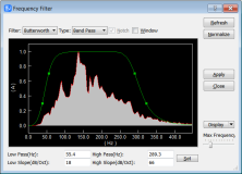
... and preprocess single shot record. You can convert data formats, analyze amplitude decay, correct trigger delay, assign geometry, mute seismic traces, run frequency filter, gain control, vertical stacking, and such. ...
type: Freeware
Download Geogiga Front Endcategories: preprocess seismic data, analyze amplitude decay, correct trigger delay, viewer, editor, correct Add to Download Basket Report virus or spyware |
 [ Zoom screenshot ] |
|
| Software Info | |
|
Best Vista Download periodically updates pricing and software information of Geogiga Front End full version from the publisher,
but some information may be out-of-date. You should confirm all information. Software piracy is theft, using crack, warez passwords, patches, serial numbers, registration codes, key generator, keymaker or keygen for Geogiga Front End license key is illegal and prevent future development of Geogiga Front End. Download links are directly from our mirrors or publisher's website, Geogiga Front End torrent files or shared files from rapidshare, yousendit or megaupload are not allowed! |
|
| Released: | October 02, 2019 |
| Filesize: | 6.02 MB |
| Platform: | Windows XP, Windows Vista, Windows Vista x64, Windows 7, Windows 7 x64 |
| Install | Instal And Uninstall |
| Add Your Review or Windows Vista Compatibility Report |
Geogiga Front End- Releases History |
| Software: | Geogiga Front End 9.0 |
| Date Released: | Oct 2, 2019 |
| Status: | New Release |
| Software: | Geogiga Front End 8.0 |
| Date Released: | Aug 20, 2015 |
| Status: | New Release |
| Software: | Geogiga Front End 7.1 |
| Date Released: | Oct 25, 2012 |
| Status: | New Release |
| Release Notes: | · Fixed the bugs in reading SEG-D and SEG-Y. |
Most popular file the data c in CAD downloads for Vista |
|
Pro Yacht 1.0.0.1 download by Marcus Bole
PolyCAD brings together the best selection of hull surface design techniques together within a user interface which allows the extensive manipulation of geometry in 3D dimensions. The software supports the direct manipulation of NURBS surfaces, ...
type: Freeware
View Details
Download
categories: calculate hydrostatic coefficient, ship displacement, design ship hull, ship, design, create |
 |
|
PreviSat 6.1.0.3 download by Astropedia
... observing purposes. Very easy to use, it shows the positions of satellites in real-time or manual mode. ... purpose is to help you monitor and observe the position of artificial satellites in real time. The ...
type: Open Source
View Details
Download
categories: track satellite, satellite tracker, satellite position, track, tracker, position |
 |
|
DXF Export Java 7 download by CADSoftTools
... with their properties, to stream or AutoCAD DXF files at high speed and with ease. Creating a new DXF file takes only one call of the exporter class, provided that user data has been ...
type: Shareware ($900.00)
View Details
Download
categories: DXF, Java, dxf in java, export dxf java, dxf export java, java dxf export, java dxf exporter, Export, Exporter, CAD, library, sdk, AutoCAD, output |
 |
|
Volocity 6.5.1 download by PerkinElmer
... a better insight to your science. Volocity is the universal solution for 3D analysis of fluorescence microscopy ... Restoration Volocity Acquisition Volocity® Acquisition is the ultimate solution for high speed, 3D image capture. ...
View Details
Download
|
 |
|
Volocity 64bit 6.5.1 download by PerkinElmer
... better insight to your science. Volocity x64 is the universal solution for 3D analysis of fluorescence microscopy ... Restoration Volocity Acquisition Volocity® Acquisition is the ultimate solution for high speed, 3D image capture. ...
type: Demo
View Details
Download
categories: imaging software x64, 3D imaging x64, 3D analysis x64, imaging x64, analysis x64, microscopy x64 |
 |
|
Gephi 0.10.1 download by Mathieu Bastian
... explore and understand graphs. Like Photoshop but for data, the user interacts with the representation, manipulate the structures, shapes and colors to reveal hidden properties. The goal is to help data analysts to make ...
type: Open Source
View Details
Download
categories: interactive visualization, exploration platform, visualization platform, visualization, exploration, graph |
 |
|
GPS Utility 5.51 download by GPS Utility Ltd.
... GPS information. You can use it to transfer data to/from a GPS receiver and store the data in PC files in one of several text formats. The program converts between different map datums and many ...
type: Demo ($60.00)
View Details
Download
categories: Waypoint Manager, GPS Receiver, Digitise GPS, Waypoint, GPD, Digitise |
 |
|
MITO 2.0 download by Giuseppe De Pietro
The "MITO - Medical Imaging TOolkit" project coagulates a ... and images stored in a PACS according to the standard format DICOM, then provides the final user with basic functionalities such as 2D-3D ...
type: Open Source
View Details
Download
categories: view DICOM file, DICOM file viewer, image segmentation, display, view, viewer |
 |
|
enCIFer 1.4 download by Cambridge Crystallographic Data Centre
The Crystallographic Information File (CIF) is the internationally agreed standard file format for information exchange in crystallography. The CIF standard is supported, maintained and developed by the International Union of Crystallography (IUCr) and most major ...
View Details
Download
|
 |
|
TNTmips 20240404 download by MicroImages, Inc.
... you work with virtually any type of geospatial data including imagery, terrain surfaces, and map data with associated database attributes. It provides all the tools you need to view, create, edit, georeference, ...
type: Freeware
View Details
Download
categories: GIS data analysis, analyze geodetic data, edit GIS dataset, GIS, dataset, editor, analysis |
 |