Related Keywords
gis downloadsgis technology downloads
gis map downloads
gis mapping software downloads
gis sdk downloads
gis software downloads
gis translator downloads
gis convertor downloads
gis calculator downloads
gis icons downloads
gis maps downloads
gis data downloads
gis editor downloads
gis viewer downloads
gis imagery downloads
gis analysis downloads
gis designer downloads
gis catalog downloads
gis map management downloads
gis library downloads
Top Software Keywords
autocad downloadscad downloads
3d cad downloads
drawing downloads
import downloads
design downloads
dwg downloads
dxf downloads
pdf to dwg downloads
convert downloads
convert pdf to dwg downloads
dwg to pdf downloads
converter downloads
dxf to pdf downloads
dwg to dxf downloads
pdf to dxf downloads
dwf to dwg downloads
dwg to jpg downloads
dwg converter downloads
dwg to bmp downloads
stl downloads
dxf to pcl downloads
dwg to tiff downloads
intellicad downloads
pdf to cad downloads
dwg to gif downloads
convert dwg to pdf downloads
dwg to png downloads
dwg to dwf downloads
dxf to ps downloads
Vista Download
Vista downloadVista antivirus download
Vista wallpaper download
Vista wallpapers download
Vista themes download
Vista pack download
Vista ultimate download
Vista home download
Vista basic download
Vista business download
Vista x64 download
Vista transformation download
Vista transformation pack download
Vista boot download
Vista dvd download
Vista sidebar download
Vista aero download
Vista product key download
Downloads RSS
Top Downloads
Top Rated
Navigation: Home
\ Graphic Apps
\ CAD \ ArcReader
ArcReader10.5.0 B6491 by ESRI |

|
Software Description:
ArcReader is a free, easy-to-use desktop mapping application that allows users to view, explore, and print maps and globes. ArcReader is a free and easy-to-use application that allows users to view and print maps that are published as Published Map Files (PMF) by the ArcGIS Publisher extension to ArcView, ArcEditor, and ArcInfo. ...
Download ArcReaderAdd to Download Basket Report virus or spyware |
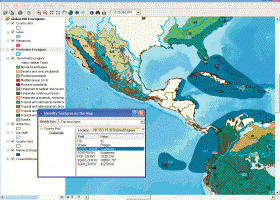 [ Zoom screenshot ] |
|
| Software Info | |
|
Best Vista Download periodically updates pricing and software information of ArcReader full version from the publisher,
but some information may be out-of-date. You should confirm all information. Software piracy is theft, using crack, warez passwords, patches, serial numbers, registration codes, key generator, keymaker or keygen for ArcReader license key is illegal and prevent future development of ArcReader. Download links are directly from our mirrors or publisher's website, ArcReader torrent files or shared files from rapidshare, yousendit or megaupload are not allowed! |
|
| Released: | February 02, 2017 |
| Filesize: | 444.00 MB |
| Platform: | Windows XP, Windows Vista, Windows Vista x64, Windows 7, Windows 7 x64, Windows 8, Windows 8 x64 |
| Install | Instal And Uninstall |
| Add Your Review or Windows Vista Compatibility Report |
ArcReader- Releases History |
| Software: | ArcReader 10.5.0 B6491 |
| Date Released: | Feb 2, 2017 |
| Status: | New Release |
| Software: | ArcReader 10.4 B5524 |
| Date Released: | Apr 10, 2016 |
| Status: | New Release |
| Software: | ArcReader 10.3 B4332 |
| Date Released: | Jan 2, 2015 |
| Status: | New Release |
Most popular gis in CAD downloads for Vista |
|
TNTmips 20240404 download by MicroImages, Inc.
... Spatial, DGN, TAB, DXF, DWG ... Full-featured GIS that integrates imagery along with geometric data including vector, CAD, shape, pinmap, and TIN formats. Maintain relational database attributes for vector, ...
type: Freeware
View Details
Download
categories: GIS data analysis, analyze geodetic data, edit GIS dataset, GIS, dataset, editor, analysis |
 |
|
Elshayal Smart 23.02 download by Elshayal Smart Web On Line Software
Elshayal Smart is the first Arabian GIS software that is completely developed by Arabian developers team and independent of any commercial software package. Download Maps from Google Earth, and ...
View Details
Download
|
 |
|
Woodland Potential Calculator 2.01 download by Michell Computing
Woodland Potential Calculator was specially developed as a data collection and presentation instrument. It is designed to calculate the potential for increasing the extent of tree cover across the north ...
type: Open Source
View Details
Download
categories: calculate potential, tree cover, potential calculation, calculator, potential, tree |
 |
|
IrriPro 3.1 download by Irriworks
... as objects containing hydraulic characteristics, geometries, materials and GIS informations obtained by Google Earth. Thanks to IrriPro's innovative technology it's now possible to calculate all the hydraulic parameters and design ...
View Details
Download
|
 |
|
Thuban for Windows 1.2.2 download by Thuban Development Team
... FreeGIS Project provides an overview of Free Software GIS projects. Many valuable and highly sophisticated tools exist, ... information. Thuban makes use of several Free GIS Software components and is itself the basis of ...
type: Open Source
View Details
Download
categories: geographic data viewer, gis viewer, analyze geographic information, information, geographic, viewer |
 |
|
FlashPoints 3.0 download by DeliCAD
FlashPoints is a tool for creating and managing points Groups (topographic points for example). FlashPoints allows you to : * import/export points coordinates from and to a file * create points ...
type: Demo ($70.00)
View Details
Download
categories: autocad, cad, dxf, xls, excel, gps, xyz, nxyz, points, import, cogo, survey, coordinates, gis, topography |
 |
|
BimRoad Plus download by HaneeSoft
... converting from two-dimensional digital map. Automatic extraction of GIS information in the digital map. Design of large file using three-dimensional TIN data and road(100km) at a time. Various visualization of ...
View Details
Download
|
 |
|
JMARS for Windows 3.1.5 download by Arizona State University
JMARS is an acronym that stands for Java Mission-planning and Analysis for Remote Sensing. It is a geospatial information system (GIS) developed by ASU's Mars Space Flight Facility to provide mission ...
type: Freeware
View Details
Download
categories: mission analysis, geospatial information, GIS analysis, mission, analysis, GIS |
 |
|
QGIS 3.36.1 download by Gary Sherman
QGIS is a professional GIS application that is built on top of and ... QGIS aims to be an easy to use GIS, providing common functions and features. The initial goal was to provide a GIS data viewer. QGIS has reached that point in ...
type: Open Source
View Details
Download
categories: geographic information system, map creator, map viewer, GIS, geographic information, create, QGIS |
 |
|
Virtual Terrain Project for Windows 1.1 110804 download by Ben Discoe
... a synergetic convergence of the fields of CAD, GIS, visual simulation, surveying and remote sensing. VTP gathers information and tracks progress in areas such as procedural scene construction, feature extraction, ...
type: Open Source
View Details
Download
categories: libraries, demos, data, open source, VirtualTerrain Project, CAD, GIS, VTP |
 |