Related Keywords
gps downloadsgps c downloads
gps clock downloads
gps decoder downloads
gps nmea sentence downloads
gps toolkit downloads
gps serial port component downloads
gps component vb downloads
gps component c downloads
gps navigation downloads
gps receivers downloads
gps express downloads
gps software downloads
gps harta downloads
gps source code module downloads
gps chartplotters downloads
gps chartplotter downloads
gps utility downloads
gps map downloads
gps freeware downloads
Top Software Keywords
tool downloadsadobe downloads
scanner downloads
jpeg downloads
digital downloads
bmp downloads
graphics downloads
image downloads
photoshop downloads
pdf downloads
design downloads
color downloads
images downloads
screen downloads
processing downloads
photo downloads
jpg downloads
graphic downloads
photos downloads
picture downloads
corel downloads
pictures downloads
utility downloads
print downloads
zoom downloads
video downloads
printing downloads
gif downloads
watermark downloads
paint downloads
Vista Download
Vista downloadVista antivirus download
Vista wallpaper download
Vista wallpapers download
Vista themes download
Vista pack download
Vista ultimate download
Vista home download
Vista basic download
Vista business download
Vista x64 download
Vista transformation download
Vista transformation pack download
Vista boot download
Vista dvd download
Vista sidebar download
Vista aero download
Vista product key download
Downloads RSS

Top Downloads
Top Rated
Navigation: Home
\ Graphic Apps
\ Other \ TatukGIS Viewer
TatukGIS Viewer5.71.0 by TatukGIS Sp. z o. o. |

|
Software Description:
... pre-defined coordinate systems, compatibility with leading database engines, GPS connectivity… For power users with specialized or advanced ... e.g., to perform Google or Bing maps integration, GPS tracking on a projected map, batch (command line) conversions between coordinate systems, and various tutorial examples. The special features or customizations can be distributed (deployed) to other Editor licensed users just by sharing the scripts.Databases: The Editor is compatible with leading database engines, e.g., MSSQL Server, MSJET, Oracle, DB2, Interbase, ... Download TatukGIS Viewer Add to Download Basket Report virus or spyware |
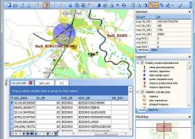 [ Zoom screenshot ] |
|
| Software Info | |
|
Best Vista Download periodically updates pricing and software information of TatukGIS Viewer full version from the publisher,
but some information may be out-of-date. You should confirm all information. Software piracy is theft, using crack, warez passwords, patches, serial numbers, registration codes, key generator, keymaker or keygen for TatukGIS Viewer license key is illegal and prevent future development of TatukGIS Viewer. Download links are directly from our mirrors or publisher's website, TatukGIS Viewer torrent files or shared files from rapidshare, yousendit or megaupload are not allowed! |
|
| Released: | April 04, 2024 |
| Filesize: | 120.00 MB |
| Platform: | Windows XP, Windows Vista, Windows Vista x64, Windows 7, Windows 7 x64, Windows 8, Windows 8 x64, Windows 10, Windows 10 x64, Windows 11 |
| Install | Instal And Uninstall |
| Add Your Review or Windows Vista Compatibility Report |
TatukGIS Viewer- Releases History |
| Software: | TatukGIS Viewer 5.71.0 |
| Date Released: | Apr 4, 2024 |
| Status: | New Release |
| Software: | TatukGIS Viewer 5.70.0 |
| Date Released: | Feb 24, 2024 |
| Status: | New Release |
| Software: | TatukGIS Viewer 5.69.0 |
| Date Released: | Jan 29, 2024 |
| Status: | New Release |
Most popular gps in Other downloads for Vista |
|
Batch Image Watermarker Lite 5.6.112 download by BinaryMark
... depth, compression... - Work with metadata: EXIF, IPTC, GPS, XMP. - Customize output file names with dynamic tags - Save images to multiple locations and using different settings - Fast ...
type: Shareware
View Details
Download
categories: batch watermark, images, image, picture, pictures, photo, photos, protect, convert, rename |
 |
|
TatukGIS Viewer 5.71.0 download by TatukGIS Sp. z o. o.
... pre-defined coordinate systems, compatibility with leading database engines, GPS connectivity… For power users with specialized or advanced ... e.g., to perform Google or Bing maps integration, GPS tracking on a projected map, batch (command line) ...
View Details
Download
|
 |
|
Mkgmap 4919 download by Steve Ratcliffe
... maps, which can then be loaded onto Garmin GPS devices and help you reach your destination quicker. ... so that it can be loaded onto compatible GPS units. If you are not already familiar ...
View Details
Download
|
 |
|
Photo Anonymizer 1.002 download by ASCOMP Software GmbH
... information. In so-called meta-tags, in addition to the GPS location, information about the recording device and even the photographer can be stored. Photo Anonymizer helps you maintain your anonymity: Remove ...
type: Freeware
View Details
Download
categories: anonymize, images, image files, fotos, photos, metadata, meta data, exif, tags, dicom, iptc |
 |
|
ExifTool 12.84 download by Phil Harvey
... number of different file formats · Reads EXIF, GPS, IPTC, XMP, JFIF, MakerNotes, GeoTIFF, ICC Profile, Photoshop IRB, FlashPix, AFCP, ID3 · Writes EXIF, GPS, IPTC, XMP, JFIF, MakerNotes, ICC Profile, Photoshop IRB, ...
type: Freeware
View Details
Download
categories: read meta data, edit meta information, write meta data, exiftool, editor, read |
 |
|
Batch Image Resizer Lite 5.6.112 download by BinaryMark
... depth, compression... - Work with metadata: EXIF, IPTC, GPS, XMP. - Customize output file names with dynamic tags - Save images to multiple locations and using different settings - Fast ...
type: Shareware
View Details
Download
categories: batch resize, images, image, picture, pictures, photo, photos, resize, convert, rename, crop, resample, change width, change height |
 |
|
Batch Image Enhancer Lite 5.6.112 download by BinaryMark
... contrast, inversion... - Work with metadata: EXIF, IPTC, GPS, XMP. - Customize output file names with dynamic tags - Save images to multiple locations and using different settings - Fast ...
type: Shareware
View Details
Download
categories: batch image, batch photo, patch picture, enhance, improve quality, remove noise, auto-adjust, white balance, sharpen, color, saturation, brightness, contrast, tint, temperature, grayscale, greyscale, sepia tone, lighten, soften, jpg, gif, png, tif, bmp, wmf, rename, preview |
 |
|
PixGPS 1.1.8 download by BR Software
... camera and get the track log from your GPS Receiver. The PixGPS Geotagger will in matter of ... You can later use other software with EXIF GPS support to view the exact location of the ...
type: Trialware ($19.95)
View Details
Download
categories: digital photo geotagging, photos EXIF metadata, photo GPS, metadata, geotag, GPS |
 |
|
ExifPro 2.1.0 download by Michal Kowalski
... appended to photographs in the IPTC standard. GPS: · Photographs with GPS information stored inside EXIF block show longitude, latitude ...
type: Freeware
View Details
Download
categories: photo browser, photo viewer, image editor, editor, browser, viewer, view exif data, rate image |
|
|
Terra Incognita 2.45 download by Zubak
... or local files maps for various programs or GPS devices. Requires Microsoft® Windows XP or Windows 8 ... large areas to many smaller map files garmin gps devices support ...
type: Open Source
View Details
Download
categories: Map Downloader, View Map, Waypoint Manager, Downloader, Viewer, GPS, Mapper |
 |