Related Keywords
grids downloadsgrids analysis downloads
resize sheridan grids ssdbgrid downloads
resize grids dbgrid downloads
data grids downloads
Top Software Keywords
autocad downloadscad downloads
3d cad downloads
drawing downloads
import downloads
design downloads
dwg downloads
dxf downloads
pdf to dwg downloads
convert downloads
convert pdf to dwg downloads
dwg to pdf downloads
converter downloads
dxf to pdf downloads
dwg to dxf downloads
pdf to dxf downloads
dwf to dwg downloads
dwg converter downloads
dwg to jpg downloads
dwg to bmp downloads
stl downloads
dxf to pcl downloads
dwg to tiff downloads
intellicad downloads
pdf to cad downloads
dwg to gif downloads
convert dwg to pdf downloads
dwg to png downloads
dwg to dwf downloads
dxf to ps downloads
Vista Download
Vista downloadVista antivirus download
Vista wallpaper download
Vista wallpapers download
Vista themes download
Vista pack download
Vista ultimate download
Vista home download
Vista basic download
Vista business download
Vista x64 download
Vista transformation download
Vista transformation pack download
Vista boot download
Vista dvd download
Vista sidebar download
Vista aero download
Vista product key download
Downloads RSS
Top Downloads
Top Rated
Navigation: Home
\ Graphic Apps
\ CAD \ GeoMapApp
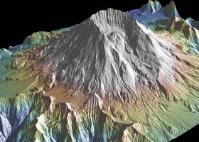
GeoMapApp3.7.1 by William Haxby |

|
Software Description:
This powerful program provides direct access to the Global Multi-Resolution Topography (GMRT) compilation. The database hosts high resolution (~100 m node spacing) bathymetry from multibeam data for ocean areas and ASTER (Advanced Spaceborne Thermal Emission and Reflection Radiometer) and NED (National Elevation Dataset) topography datasets for the global land masses. ...
type: Freeware
Download GeoMapAppcategories: geological map, geologic exploration, explore map, explore, geologic, map Add to Download Basket Report virus or spyware |
 [ Zoom screenshot ] |
|
| Software Info | |
|
Best Vista Download periodically updates pricing and software information of GeoMapApp full version from the publisher,
but some information may be out-of-date. You should confirm all information. Software piracy is theft, using crack, warez passwords, patches, serial numbers, registration codes, key generator, keymaker or keygen for GeoMapApp license key is illegal and prevent future development of GeoMapApp. Download links are directly from our mirrors or publisher's website, GeoMapApp torrent files or shared files from rapidshare, yousendit or megaupload are not allowed! |
|
| Released: | August 15, 2023 |
| Filesize: | 78.00 MB |
| Platform: | Windows 2000, Windows 2003, Windows XP, Windows Vista, Windows Vista x64, Windows 7, Windows 7 x64, Windows 8, Windows 8 x64, Windows 10, Windows 10 x64, Windows 11 |
| Requirements: | Java 8 |
| Install | Instal And Uninstall |
| Add Your Review or Windows Vista Compatibility Report |
GeoMapApp- Releases History |
| Software: | GeoMapApp 3.7.1 |
| Date Released: | Aug 15, 2023 |
| Status: | New Release |
| Release Notes: | Removed commas in saved digitized segment files. Set mask to only be controlled by the mask button, not by the transparency of a grid layer. Fixed issue with contributed grid units. Fixed issue with re-saving an imported saved session. Fixed issue with importing grids that cross the Greenwich Meridian. Fixed issue with importing NetCDF files where the COARDS compliant flag is not in the first line of the Global Attributes. Added logging of data and image downloads and saves. Fixed issue that causes 'illegal reflective access operation' warning messages when using Java 9 or higher. Fixed various issues with Digital and Analog Seismic portals. Fixed broken link on Seafloor Earthquakes and Volcanic Eruptions portal. Updated PetDB Catalog. Updated Grid Composer logic. Updated startup page. Updated Symantec code-signing certificate so Webstart version will now work again. |
| Software: | GeoMapApp 3.6.10 |
| Date Released: | Apr 10, 2019 |
| Status: | New Release |
| Release Notes: | Removed commas in saved digitized segment files. Set mask to only be controlled by the mask button, not by the transparency of a grid layer. Fixed issue with contributed grid units. Fixed issue with re-saving an imported saved session. Fixed issue with importing grids that cross the Greenwich Meridian. Fixed issue with importing NetCDF files where the COARDS compliant flag is not in the first line of the Global Attributes. Added logging of data and image downloads and saves. Fixed issue that causes 'illegal reflective access operation' warning messages when using Java 9 or higher. Fixed various issues with Digital and Analog Seismic portals. Fixed broken link on Seafloor Earthquakes and Volcanic Eruptions portal. Updated PetDB Catalog. Updated Grid Composer logic. Updated startup page. Updated Symantec code-signing certificate so Webstart version will now work again. |
Most popular grids in CAD downloads for Vista |
|
GPS Utility 5.51 download by GPS Utility Ltd.
... datums and many coordinate formats (Lat/Long, UTM/UPS, country grids etc.). Information can be filtered in various ways and waypoints sorted according to specified criteria. Route and track statistics are available ...
type: Demo ($60.00)
View Details
Download
categories: Waypoint Manager, GPS Receiver, Digitise GPS, Waypoint, GPD, Digitise |
 |
|
Harmonic Manipulator 0.9.6.1 download by Andrea Gatti
... of spherical harmonics models on sparse coordinates or grids (provided in a geodetic or geocentric reference system). It exploits basic parallelism using openmp directives. A solution with MPI has ...
type: Freeware
View Details
Download
categories: harmonics manipulation, manipulate harmonics, harmonics model, harmonics, manipulation, manipulator |
 |
|
LochMaster 4.0 download by ABACOM
... like parallel usage of mm, inch and hole grids. It is still compatible with all previous versions. ... from several board types with different layouts and grids. All required functions, like wiring, splitting tracks, soldering, ...
View Details
Download
|
 |
|
Amira 2019.2 download by Visage Imaging, Inc.
... fields · Tensors · Filament tracing · Spatial grids · Molecular visualization Analyze: · Measurement tools · Tissue statistics · Co-localization analysis · Arithmetic operations · Densitometry · Molecular ...
type: Trialware
View Details
Download
categories: 3D visualization platform, medical data viewer, Life Science visualizer, 3D visualization, Life Science, medical data |
 |
|
RISAFoundation 13.0.4 download by RISA Technologies, LLC.
... scale, delete, apply, mirror, etc. * Versatile drawing grids (orthogonal, radial, skewed) * Universal snaps allow drawing without grids * Powerful graphic select/unselect tools including box, line, ...
type: Demo ($1 050.00)
View Details
Download
categories: optimize foundation design, foundation analysis, analyze foundation, foundation, design, analyze |
 |
|
GeoMapApp 3.7.1 download by William Haxby
... and presentations. Users can import their own grids, tabular data, images, and shapefiles. For imported grids, the color palette, shaded relief, and contouring are customizable; users may also extract profiles and digitize grids. Imported table values can be edited and the ...
type: Freeware
View Details
Download
categories: geological map, geologic exploration, explore map, explore, geologic, map |
 |