Related Keywords
layer downloadslayer 3 downloads
layer 2 downloads
layer mask downloads
layer addin downloads
layer tool downloads
layer depth downloads
layer comps downloads
layer names downloads
layer string downloads
layer title downloads
layer x64 downloads
layer filter downloads
layer editing downloads
layer groups downloads
double layer dvd downloads
mpeg layer downloads
dual layer downloads
data access layer downloads
application data layer downloads
Top Software Keywords
autocad downloadscad downloads
3d cad downloads
drawing downloads
import downloads
design downloads
dwg downloads
pdf to dwg downloads
dxf downloads
convert downloads
convert pdf to dwg downloads
dwg to pdf downloads
converter downloads
dxf to pdf downloads
dwg to dxf downloads
pdf to dxf downloads
dwf to dwg downloads
dwg to jpg downloads
dwg converter downloads
dwg to bmp downloads
stl downloads
dxf to pcl downloads
dwg to tiff downloads
intellicad downloads
pdf to cad downloads
dwg to gif downloads
convert dwg to pdf downloads
dwg to png downloads
dwg to dwf downloads
dxf to ps downloads
Vista Download
Vista downloadVista antivirus download
Vista wallpaper download
Vista wallpapers download
Vista themes download
Vista pack download
Vista ultimate download
Vista home download
Vista basic download
Vista business download
Vista x64 download
Vista transformation download
Vista transformation pack download
Vista boot download
Vista dvd download
Vista sidebar download
Vista aero download
Vista product key download
Downloads RSS
Top Downloads
Top Rated
Navigation: Home
\ Graphic Apps
\ CAD \ MountainsMap Scanning Topography
MountainsMap Scanning Topography6.2.6266 by Digital Surf |

|
Software Description:
MountainsMap Scanning Topography is a professional application designed to perform surface analysis for 3D surface profilometers. With MountainsMap Scanning Topography, users will be able to easily analyze measurements and metrology data. It features an extensive set of surface texture parameters. ...
type: Trialware
Download MountainsMap Scanning Topographycategories: surface profilometer, scanning opography, surface analysis, topography, profilometer, surface Add to Download Basket Report virus or spyware |
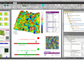 [ Zoom screenshot ] |
|
| Software Info | |
|
Best Vista Download periodically updates pricing and software information of MountainsMap Scanning Topography full version from the publisher,
but some information may be out-of-date. You should confirm all information. Software piracy is theft, using crack, warez passwords, patches, serial numbers, registration codes, key generator, keymaker or keygen for MountainsMap Scanning Topography license key is illegal and prevent future development of MountainsMap Scanning Topography. Download links are directly from our mirrors or publisher's website, MountainsMap Scanning Topography torrent files or shared files from rapidshare, yousendit or megaupload are not allowed! |
|
| Released: | September 29, 2014 |
| Filesize: | 511.00 MB |
| Platform: | Windows XP, Windows Vista, Windows Vista x64, Windows 7, Windows 7 x64 |
| Install | Instal And Uninstall |
| Add Your Review or Windows Vista Compatibility Report |
MountainsMap Scanning Topography- Releases History |
| Software: | MountainsMap Scanning Topography 6.2.6266 |
| Date Released: | May 3, 2012 |
| Status: | New Release |
| Release Notes: | Surface partitioning with or without leveling: · A sub-surface can be extracted with or without leveling using the Partition Leveling operator. Contour Analysis/Advanced Contour Analysis module enhancements: · Horizontal contour extraction with smoothing - parametric profiles extracted on the XY plane can be smoothed automatically. Integration of Chinese GB/T standards: · The "right parameters wherever you are" feature has been extended to include Chinese GB/T standard references for parameter families, which can be selected in Metrological Preferences - References. Advanced Contour Analysis module enhancements: · Automatic association of geometric elements with profiles - line segments, arcs and circles (greater than a specified minimum size) can be automatically associated with profiles. This significantly speeds up the definition of nominal form (which is otherwise carried out interactively or by fitting CAD DXF data to the profile). |
Most popular layer 3 in CAD downloads for Vista |
|
BricsCad Classic 24.2.06-1 download by Bricsys Inc.
... applies to both linear and angular dimensions. Layer states let you save and restore configurations of layer properties and states. You might want a layer to display in blue sometimes and green at ...
View Details
Download
|
 |
|
Origin 10.5.70 download by OriginLab Corp.
... all built-in graph types from toolbars · Page, Layer, Plot hierarchy to organize data plot · Plot with graph templates and organize templates using Template Library · Plot Setup dialog ...
type: Trialware ($69.00)
View Details
Download
categories: Create Graph, Create Plot, Vector Analysis, Graph, Vector, Statistics |
 |
|
TriSpace 2021.24.3.652 download by GEOSTRU
... from Geostru SRTM , from text files; Multi layer management: work plans can be associated on each level; 3D view of individual surveys or complete levels; Choice of the axis ...
type: Trialware ($500.00)
View Details
Download
categories: Terrain Calculation, 3D Terrain Viewer, View 3D Surface, Calculation, Terrain, Surface |
 |
|
CARIS Easy View 4.2.13 download by CARIS
... of files. It allows you to load multiple layers, change their order and adjust object parameters. View ... in which they are drawn and adjust each layer's display parameters. Users can also make selections and ...
View Details
Download
|
 |
|
DataNumen DWG Recovery 4.0 download by DataNumen, Inc.
... (DIAMETER), LEADER, TOLERANCE, BLOCK CONTROL OBJ, BLOCK HEADER, LAYER CONTROL OBJ, LAYER, STYLE CONTROL OBJ, STYLE, LTYPE CONTROL OBJ, LTYPE, ...
type: Shareware ($299.95)
View Details
Download
categories: DWG, AutoCAD, repair, recover, recovery, fix, dwg recovery, recover dwg, repair dwg, dwg repair, dwg fix, fix dwg, corrupt dwg, corrupted dwg, damaged dwg, dwg corruption, autocad recovery, recover autocad, repair autocad, autocad repair, fix autocad, autocad fix |
 |
|
QGIS 3.36.1 download by Gary Sherman
... analysis · On the fly projection of vector layers · Map composer · Identify features · Display ... applications · Improved MapServer export tool · Vector layer transparency and antialiasing · GRASS support in all ...
type: Open Source
View Details
Download
categories: geographic information system, map creator, map viewer, GIS, geographic information, create, QGIS |
 |
|
CADopia 23 Professional 22.3.1.4100 download by CADopia
... Stereolithography support Data Extraction Wizard Improved batch printing Layer support in PDF import The major features supported ... Dark User Interface Support for Digital Signature New Layer Manager and Palette 3D solid modeling Push & ...
type: Demo ($745.00)
View Details
Download
categories: corelcad, autocad, intellicad, bricscad, progecad, draftsight, zwcad, ARES Commander, dwg viewer, drawing viewer, drawing, dxf, dwg, survey, CAD, drafting, BIM, Revit, fusion 360 |
 |
|
TriSpace 2021.24.3.652 download by GEOSTRU
... from Geostru SRTM , from text files; Multi layer management: work plans can be associated on each level; 3D view of individual surveys or complete levels; Choice of the axis ...
type: Trialware ($500.00)
View Details
Download
categories: Terrain Calculation, 3D Terrain Viewer, View 3D Surface, Calculation, Terrain, Surface |
 |
|
Easy CAD Viewer 3.3 download by Benzsoft
... zoom to window. · Flexible pan, eyeglass, and layering control to manage complexity · Change foreground and ... weight, line types, pen style, point styles, and layer properties. · Print preview and scalability control · ...
type: Shareware ($69.00)
View Details
Download
categories: dwg, viewer, view, read, dxf, reader, dwf, color, render, open, review, pan, zoom, layer, control, rotate, design, convert, converter, conversion, shx, font, plot, plotter, print, printer, printing, annotate, autocad, cad, export, jpg, jpeg, tif, tiff, png, bmp, tga, gif, draw, drawing |
 |
|
UCL Depthmap 0.8.0 download by University College London
... and the measures may be transferred to gate layers in order to compare with indicators of pedestrian ... · OpenStreetMap, Tiger Line and Ordnance Survey ITN layer loaders · Text, SVG and EPS export ...
type: Open Source
View Details
Download
categories: urban environment, urban map, spatial network analysis, environment, map, analysis |
 |