Related Keywords
map downloadsmap drive downloads
map component downloads
map engine downloads
map network drive downloads
map serial port downloads
map files downloads
map open ports to process downloads
map point downloads
map middle earth downloads
map viewer downloads
map software downloads
map maker downloads
map editor downloads
map plot points downloads
map creator downloads
map plus personal media downloads
map plus downloads
map folder downloads
map programs downloads
Top Software Keywords
autocad downloadscad downloads
3d cad downloads
drawing downloads
import downloads
design downloads
dwg downloads
dxf downloads
pdf to dwg downloads
convert downloads
convert pdf to dwg downloads
dwg to pdf downloads
converter downloads
dxf to pdf downloads
dwg to dxf downloads
pdf to dxf downloads
dwf to dwg downloads
dwg converter downloads
dwg to jpg downloads
dwg to bmp downloads
stl downloads
dxf to pcl downloads
dwg to tiff downloads
intellicad downloads
pdf to cad downloads
dwg to gif downloads
convert dwg to pdf downloads
dwg to png downloads
dwg to dwf downloads
dxf to ps downloads
Vista Download
Vista downloadVista antivirus download
Vista wallpaper download
Vista wallpapers download
Vista themes download
Vista pack download
Vista ultimate download
Vista home download
Vista basic download
Vista business download
Vista x64 download
Vista transformation download
Vista transformation pack download
Vista boot download
Vista dvd download
Vista sidebar download
Vista aero download
Vista product key download
Downloads RSS
Top Downloads
Top Rated
Navigation: Home
\ Graphic Apps
\ CAD \ GeoMapApp
GeoMapApp3.7.1 by William Haxby |

|
Software Description:
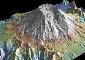
This powerful program provides direct access to the Global Multi-Resolution Topography (GMRT) compilation. The database hosts high resolution (~100 m node spacing) bathymetry from multibeam data for ocean areas and ASTER (Advanced Spaceborne Thermal Emission and Reflection Radiometer) and NED (National Elevation Dataset) topography datasets for the global land masses. ...
type: Freeware
Download GeoMapAppcategories: geological map, geologic exploration, explore map, explore, geologic, map Add to Download Basket Report virus or spyware |
 [ Zoom screenshot ] |
|
| Software Info | |
|
Best Vista Download periodically updates pricing and software information of GeoMapApp full version from the publisher,
but some information may be out-of-date. You should confirm all information. Software piracy is theft, using crack, warez passwords, patches, serial numbers, registration codes, key generator, keymaker or keygen for GeoMapApp license key is illegal and prevent future development of GeoMapApp. Download links are directly from our mirrors or publisher's website, GeoMapApp torrent files or shared files from rapidshare, yousendit or megaupload are not allowed! |
|
| Released: | August 15, 2023 |
| Filesize: | 78.00 MB |
| Platform: | Windows 2000, Windows 2003, Windows XP, Windows Vista, Windows Vista x64, Windows 7, Windows 7 x64, Windows 8, Windows 8 x64, Windows 10, Windows 10 x64, Windows 11 |
| Requirements: | Java 8 |
| Install | Instal And Uninstall |
| Add Your Review or Windows Vista Compatibility Report |
GeoMapApp- Releases History |
| Software: | GeoMapApp 3.7.1 |
| Date Released: | Aug 15, 2023 |
| Status: | New Release |
| Release Notes: | Removed commas in saved digitized segment files. Set mask to only be controlled by the mask button, not by the transparency of a grid layer. Fixed issue with contributed grid units. Fixed issue with re-saving an imported saved session. Fixed issue with importing grids that cross the Greenwich Meridian. Fixed issue with importing NetCDF files where the COARDS compliant flag is not in the first line of the Global Attributes. Added logging of data and image downloads and saves. Fixed issue that causes 'illegal reflective access operation' warning messages when using Java 9 or higher. Fixed various issues with Digital and Analog Seismic portals. Fixed broken link on Seafloor Earthquakes and Volcanic Eruptions portal. Updated PetDB Catalog. Updated Grid Composer logic. Updated startup page. Updated Symantec code-signing certificate so Webstart version will now work again. |
| Software: | GeoMapApp 3.6.10 |
| Date Released: | Apr 10, 2019 |
| Status: | New Release |
| Release Notes: | Removed commas in saved digitized segment files. Set mask to only be controlled by the mask button, not by the transparency of a grid layer. Fixed issue with contributed grid units. Fixed issue with re-saving an imported saved session. Fixed issue with importing grids that cross the Greenwich Meridian. Fixed issue with importing NetCDF files where the COARDS compliant flag is not in the first line of the Global Attributes. Added logging of data and image downloads and saves. Fixed issue that causes 'illegal reflective access operation' warning messages when using Java 9 or higher. Fixed various issues with Digital and Analog Seismic portals. Fixed broken link on Seafloor Earthquakes and Volcanic Eruptions portal. Updated PetDB Catalog. Updated Grid Composer logic. Updated startup page. Updated Symantec code-signing certificate so Webstart version will now work again. |
Most popular map in CAD downloads for Vista |
|
Thuban for Windows 1.2.2 download by Thuban Development Team
... Data Support: GeoTIFF Layer and GDAL # Comfortable Map Navigation # Object Identification and Annotation # Legend ... falls into five major parts: * Map * Legend * Statusbar * Toolbar and * ...
type: Open Source
View Details
Download
categories: geographic data viewer, gis viewer, analyze geographic information, information, geographic, viewer |
 |
|
Engauge Digitizer for Windows 12.0 download by Mark Mitchell
... converts an image file showing a graph or map, into numbers. The image file can come from ... with an image file containing a graph or map. The final result is digitized data that can ...
type: Open Source
View Details
Download
categories: digitize image, image to number, process image, digitize, convert, digitizer |
 |
|
Elshayal Smart 23.02 download by Elshayal Smart Web On Line Software
... query builder, build network, find shortest path, print map, save map image, copy map image to clipboard, save project map, edit move vertex, edit move features, snap vertexes, ... features, edit data table, modify table structure, edit map features, drawing new features, GPS, 3D, etc... ...
View Details
Download
|
 |
|
ExpertGPS 8.64 download by TopoGrafix
... you can draw your route directly on a map, search for nearby features from the millions of ... so you can quickly define an area to map and let ExpertGPS gather the data later. ExpertGPS ...
View Details
Download
|
 |
|
GPS Utility 5.51 download by GPS Utility Ltd.
... text formats. The program converts between different map datums and many coordinate formats (Lat/Long, UTM/UPS, country ... You can plot your GPS information as a map and add map annotations in text or image ...
type: Demo ($60.00)
View Details
Download
categories: Waypoint Manager, GPS Receiver, Digitise GPS, Waypoint, GPD, Digitise |
 |
|
Bifido Punnett Square Calculator Pro 3.4 download by Bifidosoft
... it includes: Punnett Square Calculator Crossing Over Map Calculator Fruit Fly Sex Calculator Recombination Progeny Calculator ...
type: Freeware
View Details
Download
categories: Punnett Square Calculator, gene calculator, Genetics Calculator, genetics, Punnett Square, calculator |
 |
|
TNTmips 20240404 download by MicroImages, Inc.
... of geospatial data including imagery, terrain surfaces, and map data with associated database attributes. It provides all ... published on the Internet as web tilesets, Web Map Service (WMS), and ArcIMS ... Automatically generate ...
type: Freeware
View Details
Download
categories: GIS data analysis, analyze geodetic data, edit GIS dataset, GIS, dataset, editor, analysis |
 |
|
Terra Excess 25.1217 download by Terra Excess Software
... Generated contours can be used as a base map for designing and implementing various construction projects or creating topographic plans and maps; CALCULATING ACCURATE VOLUMES OF STOCKPILES AND QUARRIES OR ...
type: Shareware ($298.00)
View Details
Download
categories: land surveying, civil engineering, topographic, contour lines, contour map, triangulated irregular network, earthworks, volumetric, volume calculation, cut and fill, volumes, estimating volumes, survey points, CAD, DXF, quarries, tin surface |
 |
|
TransLT 15.0 download by 3D Space
... operations: * coordinates conversions (including using a map projection); * polynomial transformations; * transformations using grid files (files containing corrections values); * transformations with parameters: 1D, 2D or 3D; ...
type: Trialware ($250.00)
View Details
Download
categories: calculate transformation parameter, coordinate transformation, transformation parameter, calculate, geodetic, GPS |
 |
|
CueMol 2.2.3.442 download by BKR Laboratory
... format), MSMS surface data, and GRASP electrostatic potential map. ...
type: Freeware
View Details
Download
categories: view macromolecular structure, macromolecular structure visualization, visualize macromolecular structure, viewer, view, visualize |
 |