Related Keywords
map downloadsmap drive downloads
map component downloads
map engine downloads
map network drive downloads
map serial port downloads
map files downloads
map open ports to process downloads
map point downloads
map middle earth downloads
map viewer downloads
map software downloads
map maker downloads
map editor downloads
map plot points downloads
map creator downloads
map plus personal media downloads
map plus downloads
map folder downloads
map programs downloads
Top Software Keywords
autocad downloadscad downloads
3d cad downloads
drawing downloads
import downloads
design downloads
dwg downloads
pdf to dwg downloads
dxf downloads
convert downloads
convert pdf to dwg downloads
dwg to pdf downloads
converter downloads
dxf to pdf downloads
dwg to dxf downloads
pdf to dxf downloads
dwf to dwg downloads
dwg to jpg downloads
dwg converter downloads
dwg to bmp downloads
stl downloads
dxf to pcl downloads
dwg to tiff downloads
intellicad downloads
pdf to cad downloads
dwg to gif downloads
convert dwg to pdf downloads
dwg to png downloads
dwg to dwf downloads
dxf to ps downloads
Vista Download
Vista downloadVista antivirus download
Vista wallpaper download
Vista wallpapers download
Vista themes download
Vista pack download
Vista ultimate download
Vista home download
Vista basic download
Vista business download
Vista x64 download
Vista transformation download
Vista transformation pack download
Vista boot download
Vista dvd download
Vista sidebar download
Vista aero download
Vista product key download
Downloads RSS
Top Downloads
Top Rated
Navigation: Home
\ Graphic Apps
\ CAD \ Terra Excess
Terra Excess25.1217 by Terra Excess Software |

|
Software Description:
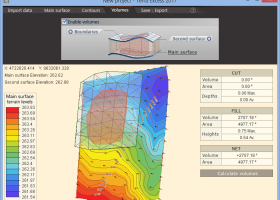
Terra Excess is land surveying and civil engineering software developed to be extremely intuitive. Even by those without previous experience, Terra Excess will allow you to handle the following tasks in just a few minutes - Generating and labeling contour lines in order to produce topographic plans and maps; Calculating accurate volumes of stockpiles and quarries or cut and fill volumes for Earthworks; Viewing and editing survey points. ...
type: Shareware ($298.00)
Download Terra Excesscategories: land surveying, civil engineering, topographic, contour lines, contour map, triangulated irregular network, earthworks, volumetric, volume calculation, cut and fill, volumes, estimating volumes, survey points, CAD, DXF, quarries, tin surface Add to Download Basket Report virus or spyware |
 [ Zoom screenshot ] |
|
| Software Info | |
|
Best Vista Download periodically updates pricing and software information of Terra Excess full version from the publisher,
but some information may be out-of-date. You should confirm all information. Software piracy is theft, using crack, warez passwords, patches, serial numbers, registration codes, key generator, keymaker or keygen for Terra Excess license key is illegal and prevent future development of Terra Excess. Download links are directly from our mirrors or publisher's website, Terra Excess torrent files or shared files from rapidshare, yousendit or megaupload are not allowed! |
|
| Released: | January 01, 2017 |
| Filesize: | 46.02 MB |
| Language: | English |
| Platform: | Win2000, Windows XP, Windows 7 x32, Windows 7 x64, Windows 8, Windows 10, WinServer, WinOther, Windows Vista, Windows Vista x64 |
| Requirements: | CPU:1.5 GHz or faster, RAM: 1 GB or more, Disk space: 190 MB, Active internet connection |
| Install | Install and Uninstall |
| Add Your Review or Windows Vista Compatibility Report |
Terra Excess- Releases History |
| Software: | Terra Excess 25.1217 |
| Date Released: | Jan 1, 2017 |
| Status: | New Release |
| Release Notes: | New Release |
| Software: | Terra Excess 25.1099 |
| Date Released: | Jan 1, 2017 |
| Status: | New Release |
| Release Notes: | New Release |
Most popular map in CAD downloads for Vista |
|
TransLT 15.0 download by 3D Space
... operations: * coordinates conversions (including using a map projection); * polynomial transformations; * transformations using grid files (files containing corrections values); * transformations with parameters: 1D, 2D or 3D; ...
type: Trialware ($250.00)
View Details
Download
categories: calculate transformation parameter, coordinate transformation, transformation parameter, calculate, geodetic, GPS |
 |
|
CueMol 2.2.3.442 download by BKR Laboratory
... format), MSMS surface data, and GRASP electrostatic potential map. ...
type: Freeware
View Details
Download
categories: view macromolecular structure, macromolecular structure visualization, visualize macromolecular structure, viewer, view, visualize |
 |
|
Mobile Atlas Creator 2.2.1 download by Fredrik Moller
... exported as one large PNG image with calibration MAP file for OziExplorer. As source for an offline ... OpenStreetMap, Google Maps, Yahoo Maps and other online map providers. Features: Create offline atlases for ...
View Details
Download
|
 |
|
Engauge Digitizer for Windows 12.0 download by Mark Mitchell
... converts an image file showing a graph or map, into numbers. The image file can come from ... with an image file containing a graph or map. The final result is digitized data that can ...
type: Open Source
View Details
Download
categories: digitize image, image to number, process image, digitize, convert, digitizer |
 |
|
GpsTools Studio 2.3.1 build 227 download by Franson Technology
... devices. The program allows you to import a map from a popular image file and to export ... The user can easily scale the map image by using the wizard available in the ...
View Details
Download
|
 |
|
GetNexrad 4.4.2 download by Carson
... 0.5 dBZ long range higher resolution images. Goggle Map overlays, real-time surface observations, and a web browser sidebar for even more real-time weather info. ...
type: Freeware
View Details
Download
categories: extract rainfall amount, DBZ analysis, view radar rainfall, view, extract, rainfall |
 |
|
CARIS Easy View 4.2.13 download by CARIS
CARIS Easy View is a simple application that enables you to view spatial data imported from numerous types of files. It allows you to load multiple layers, change their order and ...
View Details
Download
|
 |
|
QGIS 3.36.1 download by Gary Sherman
... database formats and lets you browse and create map data on your computer. QGIS supports many ... On the fly projection of vector layers · Map composer · Identify features · Display attribute table ...
type: Open Source
View Details
Download
categories: geographic information system, map creator, map viewer, GIS, geographic information, create, QGIS |
 |
|
GeoMapApp 3.7.1 download by William Haxby
GeoMapApp is a map-based application for browsing, visualizing and analyzing a diverse ... Imported table values can be edited and the map symbol, color and size are adjustable. Tabular values ... and geodetic velocity vectors. The GMRT base map provides multi-resolution global elevation data upon which other ...
type: Freeware
View Details
Download
categories: geological map, geologic exploration, explore map, explore, geologic, map |
 |
|
TrueSpace 7.61 download by Caligari Corporation
... that need different textures, and then export that map to a 2D editor so that you can draw and create the textures needed. · The scene on the right ...
type: Freeware
View Details
Download
categories: truespace 3, truespace 6.5, truespace 7, truespace 7.5, truespace, truespace 7.51, truespace trial, truespace models, True Space |
 |