Related Keywords
process file downloadsprocess file x64 downloads
process wav file downloads
file rename batch process downloads
process downloads
process manager downloads
process viewer downloads
process photo downloads
process flowchart downloads
process list downloads
process map downloads
process monitor downloads
process control downloads
process management downloads
process explorer downloads
process editor downloads
process scheduler downloads
process chart downloads
process calls downloads
process scanner downloads
Top Software Keywords
autocad downloadscad downloads
3d cad downloads
drawing downloads
import downloads
design downloads
dwg downloads
dxf downloads
pdf to dwg downloads
convert downloads
convert pdf to dwg downloads
dwg to pdf downloads
converter downloads
dxf to pdf downloads
dwg to dxf downloads
pdf to dxf downloads
dwf to dwg downloads
dwg to jpg downloads
dwg converter downloads
dwg to bmp downloads
stl downloads
dxf to pcl downloads
dwg to tiff downloads
intellicad downloads
pdf to cad downloads
dwg to gif downloads
convert dwg to pdf downloads
dwg to png downloads
dwg to dwf downloads
dxf to ps downloads
Vista Download
Vista downloadVista antivirus download
Vista wallpaper download
Vista wallpapers download
Vista themes download
Vista pack download
Vista ultimate download
Vista home download
Vista basic download
Vista business download
Vista x64 download
Vista transformation download
Vista transformation pack download
Vista boot download
Vista dvd download
Vista sidebar download
Vista aero download
Vista product key download
Downloads RSS
Top Downloads
Top Rated
Navigation: Home
\ Graphic Apps
\ CAD \ TNTmips
TNTmips20240404 by MicroImages, Inc. |

|
Software Description:
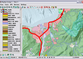
TNTmips is a geospatial image processing tool that allows you to analyze and modify GIS images. It is a professional application that can handle desktop cartography, electronic atlas preparation and spatial database management. ...
type: Freeware
Download TNTmipscategories: GIS data analysis, analyze geodetic data, edit GIS dataset, GIS, dataset, editor, analysis Add to Download Basket Report virus or spyware |
 [ Zoom screenshot ] |
|
| Software Info | |
|
Best Vista Download periodically updates pricing and software information of TNTmips full version from the publisher,
but some information may be out-of-date. You should confirm all information. Software piracy is theft, using crack, warez passwords, patches, serial numbers, registration codes, key generator, keymaker or keygen for TNTmips license key is illegal and prevent future development of TNTmips. Download links are directly from our mirrors or publisher's website, TNTmips torrent files or shared files from rapidshare, yousendit or megaupload are not allowed! |
|
| Released: | April 04, 2024 |
| Filesize: | 121.00 MB |
| Platform: | Windows XP, Windows Vista, Windows Vista x64, Windows 7, Windows 7 x64, Windows 8, Windows 8 x64, Windows 10, Windows 10 x64, Windows 11 |
| Install | Instal And Uninstall |
| Add Your Review or Windows Vista Compatibility Report |
TNTmips- Releases History |
| Software: | TNTmips 20240404 |
| Date Released: | Apr 4, 2024 |
| Status: | New Release |
| Software: | TNTmips 20240131 |
| Date Released: | Jan 31, 2024 |
| Status: | New Release |
| Software: | TNTmips 20240108 |
| Date Released: | Jan 8, 2024 |
| Status: | New Release |
Most popular process file in CAD downloads for Vista |
|
Pro Yacht 1.0.0.1 download by Marcus Bole
... tools. PolyCAD incorporates a range of powerful polyline processing functions which allow the distribution of points and ... analysis. For the expert designer, the native text file format can be used to overlay flow lines ...
type: Freeware
View Details
Download
categories: calculate hydrostatic coefficient, ship displacement, design ship hull, ship, design, create |
 |
|
2D Batch Print for AutoCAD DWG, DXF, PLT 1 download by CADSoftTools
... Print is the complete automation of the printing process of user's drawings. This program is able to print a wide range of file formats representing vector and raster graphics. It provides ...
type: Shareware ($300.00)
View Details
Download
categories: Batch Print, Batch, Print, Plot, DWG, DXF, CGM, SVG, HGL, PLT, SPL, HGL, HP2, edit, editor, view, viewer, Batch, converter, TIFF, DXF to TIFF, HPGL, Print, Printing, AutoCAD, EMF, BMP, format, Vector, HGL |
|
Engauge Digitizer for Windows 12.0 download by Mark Mitchell
... This open source, digitizing software converts an image file showing a graph or map, into numbers. The image file can come from a scanner, digital camera or ... written or copied to a spreadsheet. The process starts with an image file containing a graph ...
type: Open Source
View Details
Download
categories: digitize image, image to number, process image, digitize, convert, digitizer |
 |
|
TNTmips 20240404 download by MicroImages, Inc.
... an unsurpassed number of raster, geometric, and database file formats; convert between data types; and link to ... formats including GeoTIFF, JPEG2000, PNG, MrSID, ECW, shapefile, File Geodatabase, Oracle Spatial, DGN, TAB, DXF, DWG ... ...
type: Freeware
View Details
Download
categories: GIS data analysis, analyze geodetic data, edit GIS dataset, GIS, dataset, editor, analysis |
 |
|
CurveExpert Professional 2.7.3 download by Daniel G. Hyams
... allows thorough examination of the curve fit. The process of finding the best fit can be automated ... and output while saving your time in the process. The major features of the software are ...
View Details
Download
|
 |
|
SDMetrics 2.5 download by Jürgen Wüst
... later a fault is found in the development process, the more expensive it is to fix. SDMetrics ... SDMetrics with reverse engineering tools that produce XMI files from C++, Java, Delphi, or Smalltalk source code, ...
type: Freeware
View Details
Download
categories: analyze structural property, design metrics, establish benchmark, analyzer, analyze, measurement |
 |
|
Translev 4.16.0 download by National Geodetic Survey
This program facilitates the process of edtiting, formatting and checking digital leveling observation data and creates abstracts, bok files, and VERTOBS datasets for submission to the National ... plotting. Also included are routines for editing *.lvl files and VERTOBS files. ...
type: Freeware
View Details
Download
categories: generate Blue Book, create VERTOBS report, geodetic report, generate, create, report |
|
TopoLT 15.2 download by CADWARE Engineering
... FEATURES: · draws directly points from coordinate files, draws coordinates from total station or sends coordinates ... codes are translated according to a codes interpretation file defined by the user; · points can be ...
type: Trialware ($600.00)
View Details
Download
categories: topographical plan, cadastral plan, terrain model, topography, cadaster, terrain |
 |
|
VariCad 2011 1.06 download by VariCAD
... and tuned the GUI to reflect the thought process of a designer, so that ideas can be ... and then use it to automatically create drawings files, or you can draw only in 2D. Designing ...
type: Trialware ($690.00)
View Details
Download
categories: mechanical engineering, 3d modelling tool, mechanical part, CAD, engineering, mechanical |
 |
|
Oligo 7.56 download by Molecular Biology Insights, Inc.
... TaqMan, highly multiplexed, consensus or degenerate primers. Multiple file batch processing is possible. It is also an invaluable tool ... comprehensive. Oligo 7 can automatically select multiplex primers, process sequence files in batch modes, automatically design PCR ...
type: Demo ($1 030.00)
View Details
Download
categories: Primer Analysis, Analyze Primer, Molecular Analysis, Primer, Analysis, Gene |
 |