Related Keywords
surface analysis downloadssurface downloads
surface test downloads
surface scan downloads
surface mesh downloads
surface fitting downloads
surface area of the body downloads
surface textures downloads
surface map downloads
surface plot downloads
surface modeler downloads
surface profile downloads
surface elevations downloads
surface analyzer downloads
surface rendering downloads
surface profilometer downloads
surface based area calculation downloads
surface tab downloads
surface dist downloads
surface the soaring city downloads
Top Software Keywords
autocad downloadscad downloads
3d cad downloads
drawing downloads
import downloads
design downloads
dwg downloads
dxf downloads
pdf to dwg downloads
convert downloads
convert pdf to dwg downloads
dwg to pdf downloads
converter downloads
dxf to pdf downloads
dwg to dxf downloads
pdf to dxf downloads
dwf to dwg downloads
dwg to jpg downloads
dwg converter downloads
dwg to bmp downloads
stl downloads
dxf to pcl downloads
dwg to tiff downloads
intellicad downloads
pdf to cad downloads
dwg to gif downloads
convert dwg to pdf downloads
dwg to png downloads
dwg to dwf downloads
dxf to ps downloads
Vista Download
Vista downloadVista antivirus download
Vista wallpaper download
Vista wallpapers download
Vista themes download
Vista pack download
Vista ultimate download
Vista home download
Vista basic download
Vista business download
Vista x64 download
Vista transformation download
Vista transformation pack download
Vista boot download
Vista dvd download
Vista sidebar download
Vista aero download
Vista product key download
Downloads RSS
Top Downloads
Top Rated
Navigation: Home
\ Graphic Apps
\ CAD \ JMARS for Windows
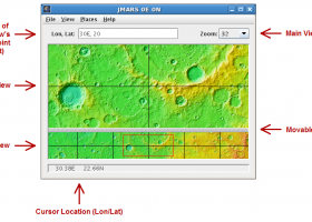
JMARS for Windows3.1.5 by Arizona State University |

|
Software Description:
... an acronym that stands for Java Mission-planning and Analysis for Remote Sensing. It is a geospatial information system (GIS) developed by ASU's Mars Space Flight Facility to provide mission planning and data-analysis tools to NASA's orbiters, instrument team members, students of all ages, and the general public. ...
type: Freeware
Download JMARS for Windowscategories: mission analysis, geospatial information, GIS analysis, mission, analysis, GIS Add to Download Basket Report virus or spyware |
 [ Zoom screenshot ] |
|
| Software Info | |
|
Best Vista Download periodically updates pricing and software information of JMARS for Windows full version from the publisher,
but some information may be out-of-date. You should confirm all information. Software piracy is theft, using crack, warez passwords, patches, serial numbers, registration codes, key generator, keymaker or keygen for JMARS for Windows license key is illegal and prevent future development of JMARS for Windows. Download links are directly from our mirrors or publisher's website, JMARS for Windows torrent files or shared files from rapidshare, yousendit or megaupload are not allowed! |
|
| Released: | August 12, 2014 |
| Filesize: | 50.00 MB |
| Platform: | Windows Vista, Windows Vista x64, Windows 7, Windows 7 x64 |
| Install | Instal And Uninstall |
| Add Your Review or Windows Vista Compatibility Report |
JMARS for Windows- Releases History |
| Software: | JMARS for Windows 3.1.5 |
| Date Released: | Aug 12, 2014 |
| Status: | New Release |
| Release Notes: | - In JMARS, locate the "Options" tab at the top of the screen, click it - Click "Check for Updates" |
| Software: | JMARS for Windows 3.0.4 |
| Date Released: | Jun 7, 2013 |
| Status: | New Release |
| Release Notes: | - minor change that will allow users to use Body->reset layers to reset layers to JMARS default/startup state - minor bug fix in the interaction of the Main view and Panner views - accuracy of crater layer settings improved when saving crater layers as part of a saved session - more graceful error handling when loading a saved session - removed the ESRI option from the list for loading/saving in the shape layer. The Geo tools ESRI option is the replacement - a fix for a drawing issue in the TES layer on Mac OS X running Java 7 - lower right corner coordinates added to the high resolution export tool including new UI functionality for setting export height and width - update to how image corners (lat/lon) are specified in high resolution export - added CSV export and look and feel changes to the Investigate tool - improved communication between the Stamp Layer and backend databases - Add Layer UI look and feel improvements - ease of use changes to crater counting layer for small bodies |
Most popular surface analysis in CAD downloads for Vista |
|
Pro Yacht 1.0.0.1 download by Marcus Bole
PolyCAD brings together the best selection of hull surface design techniques together within a user interface which ... The software supports the direct manipulation of NURBS surfaces, parametric hull generation and advanced techniques such as ...
type: Freeware
View Details
Download
categories: calculate hydrostatic coefficient, ship displacement, design ship hull, ship, design, create |
 |
|
TNTmips 20240404 download by MicroImages, Inc.
... any type of geospatial data including imagery, terrain surfaces, and map data with associated database attributes. It ... and transform representations of natural terrains and mathematical surfaces from 3D information. Fast and efficient Surface Fitting, ...
type: Freeware
View Details
Download
categories: GIS data analysis, analyze geodetic data, edit GIS dataset, GIS, dataset, editor, analysis |
 |
|
3D FastView 1.0 download by Gstarsoft Co.,Ltd.
... before manufacturing by calculating the projected area, undercut analysis, draft angle analysis, 2D/3D model compare, etc. * Assembly The advanced ... measurement by using traditional 2D markup tools, applying surface and 3D annotation labels, calculating surface areas, volumes, ...
View Details
Download
|
 |
|
GOM Inspect 7.5 SR1 download by GOM
... 3D inspection and mesh processing software for dimensional analysis of 3D point clouds and viewer for ATOS ... Import 3D Mesh Processing 3D Inspection Tools 2D Analysis Comprehensive Reporting Data Export Extensive, certified inspection ...
View Details
Download
|
 |
|
DataScene Deluxe 3.2.3.9 download by CyberWit, Inc.
DataScene is a data graphing, animation, and analysis software package. It allows the user to easily ... 2D & 3D graphs (Area, Bar, Pie, Line, Surface, Ploar, and more) with scientific, financial, and statistical ...
type: Trialware ($219.00)
View Details
Download
categories: plot 2d graph, plot 3d graph, plot mathematical graph, plot, graph, mathematical |
 |
|
Gwyddion 2.66 download by David Necas and Petr Klapetek
... for SPM (scanning probe microscopy) data visualization and analysis. Primarily it is intended for analysis of height fields obtained by scanning probe microscopy ... used for any other height field and image analysis, for instance for analysis of profilometry data (learn ...
type: Open Source
View Details
Download
categories: data visualization, data analysis, height field analysis, analyze, visualize, visualizer |
 |
|
JMARS for Windows 3.1.5 download by Arizona State University
... an acronym that stands for Java Mission-planning and Analysis for Remote Sensing. It is a geospatial information ... registered multilayer image. * Make topographic profiles, extract surface temperatures (day or night), plot footprints and render ...
type: Freeware
View Details
Download
categories: mission analysis, geospatial information, GIS analysis, mission, analysis, GIS |
 |
|
Amira 2019.2 download by Visage Imaging, Inc.
... Ortho and oblique slicing · Volume rendering · Surface rendering · Isolines and isosurfaces · Multichannel imaging ... · Measurement tools · Tissue statistics · Co-localization analysis · Arithmetic operations · Densitometry · Molecular analysis ...
type: Trialware
View Details
Download
categories: 3D visualization platform, medical data viewer, Life Science visualizer, 3D visualization, Life Science, medical data |
 |
|
Maxsurf 17.07 download by Bentley Systems
... and appendages. An unlimited number of trimmed NURB surfaces can be used to model any vessel from ... with limited training time. Any number of NURB surfaces can be joined, trimmed and manipulated to create ...
View Details
Download
|
|
|
FOIL Release 4.5 download by Vacanti Yacht Design LLC
Vacanti Yacht Design LLC FOIL Design and Analysis program provides a Windows CAD user interface and CAD file export for the well known Eppler Analysis code package. Valid for Reynolds Number (Less than ...
type: Demo ($199.00)
View Details
Download
categories: performance assessment, foil performance, assess hydrofoil, foil, hydrofoil, performance |