Related Keywords
surface analysis downloadssurface downloads
surface test downloads
surface scan downloads
surface mesh downloads
surface fitting downloads
surface area of the body downloads
surface textures downloads
surface map downloads
surface plot downloads
surface modeler downloads
surface profile downloads
surface elevations downloads
surface analyzer downloads
surface rendering downloads
surface profilometer downloads
surface based area calculation downloads
surface tab downloads
surface dist downloads
surface the soaring city downloads
Top Software Keywords
autocad downloadscad downloads
3d cad downloads
drawing downloads
import downloads
design downloads
dwg downloads
dxf downloads
pdf to dwg downloads
convert downloads
convert pdf to dwg downloads
dwg to pdf downloads
converter downloads
dxf to pdf downloads
dwg to dxf downloads
pdf to dxf downloads
dwf to dwg downloads
dwg to jpg downloads
dwg converter downloads
dwg to bmp downloads
stl downloads
dxf to pcl downloads
dwg to tiff downloads
intellicad downloads
pdf to cad downloads
dwg to gif downloads
convert dwg to pdf downloads
dwg to png downloads
dwg to dwf downloads
dxf to ps downloads
Vista Download
Vista downloadVista antivirus download
Vista wallpaper download
Vista wallpapers download
Vista themes download
Vista pack download
Vista ultimate download
Vista home download
Vista basic download
Vista business download
Vista x64 download
Vista transformation download
Vista transformation pack download
Vista boot download
Vista dvd download
Vista sidebar download
Vista aero download
Vista product key download
Downloads RSS
Top Downloads
Top Rated
Navigation: Home
\ Graphic Apps
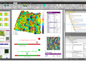
\ CAD \ MountainsMap Scanning Topography
MountainsMap Scanning Topography6.2.6266 by Digital Surf |

|
Software Description:
... Topography is a professional application designed to perform surface analysis for 3D surface profilometers. With MountainsMap Scanning Topography, users will be ... metrology data. It features an extensive set of surface texture parameters. ...
type: Trialware
Download MountainsMap Scanning Topographycategories: surface profilometer, scanning opography, surface analysis, topography, profilometer, surface Add to Download Basket Report virus or spyware |
 [ Zoom screenshot ] |
|
| Software Info | |
|
Best Vista Download periodically updates pricing and software information of MountainsMap Scanning Topography full version from the publisher,
but some information may be out-of-date. You should confirm all information. Software piracy is theft, using crack, warez passwords, patches, serial numbers, registration codes, key generator, keymaker or keygen for MountainsMap Scanning Topography license key is illegal and prevent future development of MountainsMap Scanning Topography. Download links are directly from our mirrors or publisher's website, MountainsMap Scanning Topography torrent files or shared files from rapidshare, yousendit or megaupload are not allowed! |
|
| Released: | September 29, 2014 |
| Filesize: | 511.00 MB |
| Platform: | Windows XP, Windows Vista, Windows Vista x64, Windows 7, Windows 7 x64 |
| Install | Instal And Uninstall |
| Add Your Review or Windows Vista Compatibility Report |
MountainsMap Scanning Topography- Releases History |
| Software: | MountainsMap Scanning Topography 6.2.6266 |
| Date Released: | May 3, 2012 |
| Status: | New Release |
| Release Notes: | Surface partitioning with or without leveling: · A sub-surface can be extracted with or without leveling using the Partition Leveling operator. Contour Analysis/Advanced Contour Analysis module enhancements: · Horizontal contour extraction with smoothing - parametric profiles extracted on the XY plane can be smoothed automatically. Integration of Chinese GB/T standards: · The "right parameters wherever you are" feature has been extended to include Chinese GB/T standard references for parameter families, which can be selected in Metrological Preferences - References. Advanced Contour Analysis module enhancements: · Automatic association of geometric elements with profiles - line segments, arcs and circles (greater than a specified minimum size) can be automatically associated with profiles. This significantly speeds up the definition of nominal form (which is otherwise carried out interactively or by fitting CAD DXF data to the profile). |
Most popular surface analysis in CAD downloads for Vista |
|
Pro Yacht 1.0.0.1 download by Marcus Bole
PolyCAD brings together the best selection of hull surface design techniques together within a user interface which ... The software supports the direct manipulation of NURBS surfaces, parametric hull generation and advanced techniques such as ...
type: Freeware
View Details
Download
categories: calculate hydrostatic coefficient, ship displacement, design ship hull, ship, design, create |
 |
|
TNTmips 20240404 download by MicroImages, Inc.
... any type of geospatial data including imagery, terrain surfaces, and map data with associated database attributes. It ... and transform representations of natural terrains and mathematical surfaces from 3D information. Fast and efficient Surface Fitting, ...
type: Freeware
View Details
Download
categories: GIS data analysis, analyze geodetic data, edit GIS dataset, GIS, dataset, editor, analysis |
 |
|
3D FastView 1.0 download by Gstarsoft Co.,Ltd.
... before manufacturing by calculating the projected area, undercut analysis, draft angle analysis, 2D/3D model compare, etc. * Assembly The advanced ... measurement by using traditional 2D markup tools, applying surface and 3D annotation labels, calculating surface areas, volumes, ...
View Details
Download
|
 |
|
GOM Inspect 7.5 SR1 download by GOM
... 3D inspection and mesh processing software for dimensional analysis of 3D point clouds and viewer for ATOS ... Import 3D Mesh Processing 3D Inspection Tools 2D Analysis Comprehensive Reporting Data Export Extensive, certified inspection ...
View Details
Download
|
 |
|
JMARS for Windows 3.1.5 download by Arizona State University
... an acronym that stands for Java Mission-planning and Analysis for Remote Sensing. It is a geospatial information ... registered multilayer image. * Make topographic profiles, extract surface temperatures (day or night), plot footprints and render ...
type: Freeware
View Details
Download
categories: mission analysis, geospatial information, GIS analysis, mission, analysis, GIS |
 |
|
DataScene Deluxe 3.2.3.9 download by CyberWit, Inc.
DataScene is a data graphing, animation, and analysis software package. It allows the user to easily ... 2D & 3D graphs (Area, Bar, Pie, Line, Surface, Ploar, and more) with scientific, financial, and statistical ...
type: Trialware ($219.00)
View Details
Download
categories: plot 2d graph, plot 3d graph, plot mathematical graph, plot, graph, mathematical |
 |
|
Gwyddion 2.66 download by David Necas and Petr Klapetek
... for SPM (scanning probe microscopy) data visualization and analysis. Primarily it is intended for analysis of height fields obtained by scanning probe microscopy ... used for any other height field and image analysis, for instance for analysis of profilometry data (learn ...
type: Open Source
View Details
Download
categories: data visualization, data analysis, height field analysis, analyze, visualize, visualizer |
 |
|
FOIL Release 4.5 download by Vacanti Yacht Design LLC
Vacanti Yacht Design LLC FOIL Design and Analysis program provides a Windows CAD user interface and CAD file export for the well known Eppler Analysis code package. Valid for Reynolds Number (Less than ...
type: Demo ($199.00)
View Details
Download
categories: performance assessment, foil performance, assess hydrofoil, foil, hydrofoil, performance |
|
GetNexrad 4.4.2 download by Carson
... range higher resolution images. Goggle Map overlays, real-time surface observations, and a web browser sidebar for even more real-time weather info. ...
type: Freeware
View Details
Download
categories: extract rainfall amount, DBZ analysis, view radar rainfall, view, extract, rainfall |
 |
|
CADbro 2020 download by ZWSOFT CO., LTD.(Guangzhou)
... Distance, Radius/Diametric, Angular, Coordinate Datum, Feature Control Symbol, Surface Finish Symbol Label, Text, Image Balloon Advanced Analysis With diversified query & analysis tools in CADbro, you can verify the manufacturability ... cost and save the time. Key features of Analysis: Mass Properties, such as volume, area, mass Draft ...
type: Shareware ($1 500.00)
View Details
Download
categories: CAD viewer, Cloud, 3D CAD viewer, 3D viewer, 3D converter, CAD converter, 3D translator, CAD translator, Catia viewer, Solidworks viewer, DWG viewer, DXF viewer, Creo viewer, PTC viewer, UG viewer, STL viewer, Step viewer, DWG converter, DXF converte |
 |