Related Keywords
surface downloadssurface test downloads
surface scan downloads
surface mesh downloads
surface fitting downloads
surface area of the body downloads
surface textures downloads
surface map downloads
surface plot downloads
surface modeler downloads
surface profile downloads
surface elevations downloads
surface analyzer downloads
surface rendering downloads
surface profilometer downloads
surface analysis downloads
surface based area calculation downloads
surface tab downloads
surface dist downloads
surface the soaring city downloads
Top Software Keywords
autocad downloadscad downloads
3d cad downloads
drawing downloads
import downloads
design downloads
dwg downloads
pdf to dwg downloads
dxf downloads
convert downloads
convert pdf to dwg downloads
dwg to pdf downloads
converter downloads
dxf to pdf downloads
pdf to dxf downloads
dwg to dxf downloads
dwf to dwg downloads
dwg converter downloads
dwg to jpg downloads
dwg to bmp downloads
stl downloads
dxf to pcl downloads
dwg to tiff downloads
intellicad downloads
pdf to cad downloads
dwg to gif downloads
convert dwg to pdf downloads
dwg to png downloads
dwg to dwf downloads
dxf to ps downloads
Vista Download
Vista downloadVista antivirus download
Vista wallpaper download
Vista wallpapers download
Vista themes download
Vista pack download
Vista ultimate download
Vista home download
Vista basic download
Vista business download
Vista x64 download
Vista transformation download
Vista transformation pack download
Vista boot download
Vista dvd download
Vista sidebar download
Vista aero download
Vista product key download
Downloads RSS
Top Downloads
Top Rated
Navigation: Home
\ Graphic Apps
\ CAD \ TriSpace
TriSpace2021.24.3.652 by GEOSTRU |

|
Software Description:
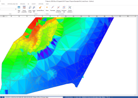
TriSpace is a comprehensive application designed to provide users with a simple means of calculating and viewing terrains.TriSpace is worth having especially in geological fields due to the extreme facility in creating longitudinal sections. The aforementioned application also provides you with standard graphic objects such as polygons, arches and rectangles that allow you to indicate perimeters or excluded areas. ...
type: Trialware ($500.00)
Download TriSpacecategories: Terrain Calculation, 3D Terrain Viewer, View 3D Surface, Calculation, Terrain, Surface Add to Download Basket Report virus or spyware |
 [ Zoom screenshot ] |
|
| Software Info | |
|
Best Vista Download periodically updates pricing and software information of TriSpace full version from the publisher,
but some information may be out-of-date. You should confirm all information. Software piracy is theft, using crack, warez passwords, patches, serial numbers, registration codes, key generator, keymaker or keygen for TriSpace license key is illegal and prevent future development of TriSpace. Download links are directly from our mirrors or publisher's website, TriSpace torrent files or shared files from rapidshare, yousendit or megaupload are not allowed! |
|
| Released: | January 21, 2021 |
| Filesize: | 15.30 MB |
| Platform: | Windows XP, Windows Vista, Windows Vista x64, Windows 7, Windows 7 x64, Windows 8, Windows 8 x64, Windows 10, Windows 10 x64 |
| Install | Instal And Uninstall |
| Add Your Review or Windows Vista Compatibility Report |
TriSpace- Releases History |
| Software: | TriSpace 2021.24.3.65 |
| Date Released: | Jan 21, 2021 |
| Status: | New Release |
Most popular surface in CAD downloads for Vista |
|
PyMOL 3.0.3 download by DeLano Scientific LLC
... 20 different ways. Spheres provides a CPK-like view, surface and mesh provide more volumetric views, lines and sticks put the emphasis on bond connectivity, and ribbon and cartoon are popular ...
type: Shareware ($99.00)
View Details
Download
categories: molecular visualization, molecular model, 3D molecular structure, molecular, visualization, structure |
 |
|
Multiwfn 3.7 download by sobereva
... and can be viewed in terms of iso surface. Setting up grid is very flexible and convenient. ... terms of 3D or plane graph. Interbasin · surfaces can be drawn. · Checking and modifying wavefunction. ...
type: Open Source
View Details
Download
categories: wavefunction analysis, topology analysis, molecular structure, analysis, analize, wavefunction |
 |
|
StmProps 1.1.3 download by GP Engineering Software
StmProps is an advanced steam table property calculator for technical and engineering professionals for Windows (tm) based computer systems. Steam property calculations can be performed in either IP (US Imperial) or ...
type: Trialware ($20.00)
View Details
Download
categories: calculate surface tension, steam table calculator, estimate thermal conductivity, calculate, calculator, estimate |
 |
|
DAVID-Laserscanner 5.6.0.2037 download by Simon Winkelbach
... automatically calculates 3D coordinates of the scanned object surface. See our gallery to get an impression of the software. To obtain a complete 360 degree model of your 3d ...
View Details
Download
|
 |
|
Aqsis Renderer for Windows 1.8.2 download by Aqsis Team
... motion blur, NURBS, procedural plugins, programmable shading, subdivision surfaces, subpixel displacements and more. The Aqsis tools ... Occlusion * Arbitrary Output Variables (AOV) * Subdivision Surfaces (SDS) * High quality texture mapping * Level ...
type: Freeware
View Details
Download
categories: 3D render solution, programmable shade, true displacement, render, renderer, shade, aqsis, aqsis rendererhttp://pads.websys.sk/pads.php?action=edit_pad&pID=3997 |
 |
|
TopoLT 15.2 download by CADWARE Engineering
... restrictions (the volume obtained by intersecting a 3D surface with a plane or the volume between two 3D surfaces of any grid form or triangles); · 3D ...
type: Trialware ($600.00)
View Details
Download
categories: topographical plan, cadastral plan, terrain model, topography, cadaster, terrain |
 |
|
Gwyddion 2.66 download by David Necas and Petr Klapetek
... kernel · statistical functions: Ra, RMS, projected and surface area, inclination, histograms, 1D and 2D correlation functions, PSDF, 1D and 2D angular distributions, Minkowski functionals, facet orientation analysis · statistical ...
type: Open Source
View Details
Download
categories: data visualization, data analysis, height field analysis, analyze, visualize, visualizer |
 |
|
CueMol 2.2.3.442 download by BKR Laboratory
... density (CCP4, CNS , and BRIX format), MSMS surface data, and GRASP electrostatic potential map. ...
type: Freeware
View Details
Download
categories: view macromolecular structure, macromolecular structure visualization, visualize macromolecular structure, viewer, view, visualize |
 |
|
Pro Yacht 1.0.0.1 download by Marcus Bole
PolyCAD brings together the best selection of hull surface design techniques together within a user interface which ... The software supports the direct manipulation of NURBS surfaces, parametric hull generation and advanced techniques such as ...
type: Freeware
View Details
Download
categories: calculate hydrostatic coefficient, ship displacement, design ship hull, ship, design, create |
 |
|
Maxsurf 17.07 download by Bentley Systems
... and appendages. An unlimited number of trimmed NURB surfaces can be used to model any vessel from ... with limited training time. Any number of NURB surfaces can be joined, trimmed and manipulated to create ...
View Details
Download
|
 |