Related Keywords
system image downloadssystem image backup downloads
system image backup tool downloads
system image tool downloads
deploying system image downloads
image into nude image downloads
image cut (image splitter) downloads
image within an image downloads
image cut image splitter downloads
image resize photos change size image resizer downloads
system downloads
system registry downloads
system integration downloads
system keno downloads
system info downloads
system monitor downloads
system monitoring downloads
system commander downloads
system tray downloads
system tool downloads
Top Software Keywords
autocad downloadscad downloads
3d cad downloads
drawing downloads
import downloads
design downloads
dwg downloads
dxf downloads
pdf to dwg downloads
convert downloads
convert pdf to dwg downloads
dwg to pdf downloads
converter downloads
dxf to pdf downloads
dwg to dxf downloads
pdf to dxf downloads
dwf to dwg downloads
dwg converter downloads
dwg to jpg downloads
dwg to bmp downloads
stl downloads
dxf to pcl downloads
dwg to tiff downloads
intellicad downloads
pdf to cad downloads
dwg to gif downloads
convert dwg to pdf downloads
dwg to png downloads
dwg to dwf downloads
dxf to ps downloads
Vista Download
Vista downloadVista antivirus download
Vista wallpaper download
Vista wallpapers download
Vista themes download
Vista pack download
Vista ultimate download
Vista home download
Vista basic download
Vista business download
Vista x64 download
Vista transformation download
Vista transformation pack download
Vista boot download
Vista dvd download
Vista sidebar download
Vista aero download
Vista product key download
Downloads RSS
Top Downloads
Top Rated
Navigation: Home
\ Graphic Apps
\ CAD \ TNTmips
TNTmips20240404 by MicroImages, Inc. |

|
Software Description:
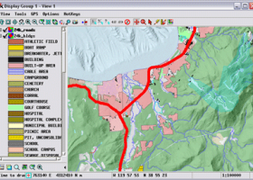
TNTmips is a geospatial image processing tool that allows you to analyze and modify GIS images. It is a professional application that can handle desktop cartography, electronic atlas preparation and spatial database management. ...
type: Freeware
Download TNTmipscategories: GIS data analysis, analyze geodetic data, edit GIS dataset, GIS, dataset, editor, analysis Add to Download Basket Report virus or spyware |
 [ Zoom screenshot ] |
|
| Software Info | |
|
Best Vista Download periodically updates pricing and software information of TNTmips full version from the publisher,
but some information may be out-of-date. You should confirm all information. Software piracy is theft, using crack, warez passwords, patches, serial numbers, registration codes, key generator, keymaker or keygen for TNTmips license key is illegal and prevent future development of TNTmips. Download links are directly from our mirrors or publisher's website, TNTmips torrent files or shared files from rapidshare, yousendit or megaupload are not allowed! |
|
| Released: | April 04, 2024 |
| Filesize: | 121.00 MB |
| Platform: | Windows XP, Windows Vista, Windows Vista x64, Windows 7, Windows 7 x64, Windows 8, Windows 8 x64, Windows 10, Windows 10 x64, Windows 11 |
| Install | Instal And Uninstall |
| Add Your Review or Windows Vista Compatibility Report |
TNTmips- Releases History |
| Software: | TNTmips 20240404 |
| Date Released: | Apr 4, 2024 |
| Status: | New Release |
| Software: | TNTmips 20240131 |
| Date Released: | Jan 31, 2024 |
| Status: | New Release |
| Software: | TNTmips 20240108 |
| Date Released: | Jan 8, 2024 |
| Status: | New Release |
Most popular system image in CAD downloads for Vista |
|
Elshayal Smart 23.02 download by Elshayal Smart Web On Line Software
... save GPS route and View and Rectify Raster Images gif, jpg, bmp and Edit shape files, build ... network, find shortest path, print map, save map image, copy map image to clipboard, save project map, ...
View Details
Download
|
 |
|
Acme CAD See 6.6 download by DWG TOOL Software
... one. A full-featured drawing viewer quickly displays your images in high quality. The drawing file browser lets ... interface that allows you to locate and manage images stored in your file system. This is the ...
View Details
Download
|
 |
|
TNTmips 20240404 download by MicroImages, Inc.
TNTmips software is a complete Geographic Information System (GIS) that lets you work with virtually any type of geospatial data including imagery, terrain surfaces, and map data with associated database ... data types and a multitude of Coordinate Reference Systems. Include layers in a wide variety of external ...
type: Freeware
View Details
Download
categories: GIS data analysis, analyze geodetic data, edit GIS dataset, GIS, dataset, editor, analysis |
 |
|
CADopia 23 Professional 22.3.1.4100 download by CADopia
... block Edit block attribute properties Dynamic custom coordinate system Formulas in tables and export to Excel Multileaders ... files for viewing drawings on the Internet Raster Image insertion and editing Clipping support for references, images, ...
type: Demo ($745.00)
View Details
Download
categories: corelcad, autocad, intellicad, bricscad, progecad, draftsight, zwcad, ARES Commander, dwg viewer, drawing viewer, drawing, dxf, dwg, survey, CAD, drafting, BIM, Revit, fusion 360 |
 |
|
Acme CADSee 2018 6.6 download by DWG TOOL Software
... one. A full-featured drawing viewer quickly displays your images in high quality. The drawing file browser lets ... interface that allows you to locate and manage images stored in your file system. This is the ...
type: Demo ($59.95)
View Details
Download
categories: AutoCAD viewer, AutoCAD browser, AutoCAD print, AutoCAD, viewer, view |
 |
|
Easy CAD Solution Suite 3.3 download by Benzsoft
Convert your CAD drawings to various image and graphics formats without the need for AutoCAD-based ... between DWG, DXF, DWF, PDF, SVG, and various image formats without the need for AutoCAD. The output ...
type: Shareware ($199.00)
View Details
Download
categories: cad, solutions, solution, pack, svg, jpg, image, jpeg, tif, tiff, png, tga, pdf, gif, bmp, dwg, dxf, dwf, software, easy, suite, package, value, discount, free cad, freeware, shareware |
 |
|
TopoLT 15.2 download by CADWARE Engineering
... and contours, fill and cut volumes calculation, raster image georeferencing and automatic printing. TopoLT is running on ... movies can be saved with moving three-dimensional objects, images can be saved, 3ds files can be visualized, ...
type: Trialware ($600.00)
View Details
Download
categories: topographical plan, cadastral plan, terrain model, topography, cadaster, terrain |
 |
|
JMARS for Windows 3.1.5 download by Arizona State University
... for Remote Sensing. It is a geospatial information system (GIS) developed by ASU's Mars Space Flight Facility ... terabyte of NASA orbiter data, and has basic image and vector processing features to conveniently compare, plot, ...
type: Freeware
View Details
Download
categories: mission analysis, geospatial information, GIS analysis, mission, analysis, GIS |
 |
|
CADopia 23 Professional 22.3.1.4100 download by CADopia
... block Edit block attribute properties Dynamic custom coordinate system Formulas in tables and export to Excel Multileaders ... files for viewing drawings on the Internet Raster Image insertion and editing Clipping support for references, images, ...
type: Demo ($745.00)
View Details
Download
categories: corelcad, autocad, intellicad, bricscad, progecad, draftsight, zwcad, ARES Commander, dwg viewer, drawing viewer, drawing, dxf, dwg, survey, CAD, drafting, BIM, Revit, fusion 360 |
 |
|
CADbro 2020 download by ZWSOFT CO., LTD.(Guangzhou)
... like STEP, IGES, JT without expensive 3D CAD system. CADbro Cloud allows you to communicate 3D CAD ... Feature Control Symbol, Surface Finish Symbol Label, Text, Image Balloon Advanced Analysis With diversified query & analysis ...
type: Shareware ($1 500.00)
View Details
Download
categories: CAD viewer, Cloud, 3D CAD viewer, 3D viewer, 3D converter, CAD converter, 3D translator, CAD translator, Catia viewer, Solidworks viewer, DWG viewer, DXF viewer, Creo viewer, PTC viewer, UG viewer, STL viewer, Step viewer, DWG converter, DXF converte |
 |