Related Keywords
system program downloadsprevent system program files folder downloads
system cleaner tool program downloads
system repair tool program downloads
system information program downloads
program downloads
program editor downloads
program submission downloads
program launcher downloads
program flowchart downloads
program icon downloads
program launch downloads
program calendar downloads
program trading downloads
program restrictions downloads
program that renames mp3 files downloads
program protect downloads
program lock downloads
program installer downloads
program access downloads
Top Software Keywords
autocad downloadscad downloads
3d cad downloads
drawing downloads
import downloads
design downloads
dwg downloads
dxf downloads
pdf to dwg downloads
convert downloads
convert pdf to dwg downloads
dwg to pdf downloads
converter downloads
dxf to pdf downloads
dwg to dxf downloads
pdf to dxf downloads
dwf to dwg downloads
dwg to jpg downloads
dwg converter downloads
dwg to bmp downloads
stl downloads
dxf to pcl downloads
dwg to tiff downloads
intellicad downloads
pdf to cad downloads
dwg to gif downloads
convert dwg to pdf downloads
dwg to png downloads
dwg to dwf downloads
dxf to ps downloads
Vista Download
Vista downloadVista antivirus download
Vista wallpaper download
Vista wallpapers download
Vista themes download
Vista pack download
Vista ultimate download
Vista home download
Vista basic download
Vista business download
Vista x64 download
Vista transformation download
Vista transformation pack download
Vista boot download
Vista dvd download
Vista sidebar download
Vista aero download
Vista product key download
Downloads RSS
Top Downloads
Top Rated
Navigation: Home
\ Graphic Apps
\ CAD \ GeoMapApp
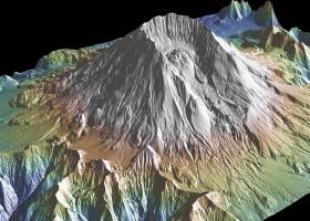
GeoMapApp3.7.1 by William Haxby |

|
Software Description:
This powerful program provides direct access to the Global Multi-Resolution Topography (GMRT) compilation. The database hosts high resolution (~100 m node spacing) bathymetry from multibeam data for ocean areas and ASTER (Advanced Spaceborne Thermal Emission and Reflection Radiometer) and NED (National Elevation Dataset) topography datasets for the global land masses. ...
type: Freeware
Download GeoMapAppcategories: geological map, geologic exploration, explore map, explore, geologic, map Add to Download Basket Report virus or spyware |
 [ Zoom screenshot ] |
|
| Software Info | |
|
Best Vista Download periodically updates pricing and software information of GeoMapApp full version from the publisher,
but some information may be out-of-date. You should confirm all information. Software piracy is theft, using crack, warez passwords, patches, serial numbers, registration codes, key generator, keymaker or keygen for GeoMapApp license key is illegal and prevent future development of GeoMapApp. Download links are directly from our mirrors or publisher's website, GeoMapApp torrent files or shared files from rapidshare, yousendit or megaupload are not allowed! |
|
| Released: | August 15, 2023 |
| Filesize: | 78.00 MB |
| Platform: | Windows 2000, Windows 2003, Windows XP, Windows Vista, Windows Vista x64, Windows 7, Windows 7 x64, Windows 8, Windows 8 x64, Windows 10, Windows 10 x64, Windows 11 |
| Requirements: | Java 8 |
| Install | Instal And Uninstall |
| Add Your Review or Windows Vista Compatibility Report |
GeoMapApp- Releases History |
| Software: | GeoMapApp 3.7.1 |
| Date Released: | Aug 15, 2023 |
| Status: | New Release |
| Release Notes: | Removed commas in saved digitized segment files. Set mask to only be controlled by the mask button, not by the transparency of a grid layer. Fixed issue with contributed grid units. Fixed issue with re-saving an imported saved session. Fixed issue with importing grids that cross the Greenwich Meridian. Fixed issue with importing NetCDF files where the COARDS compliant flag is not in the first line of the Global Attributes. Added logging of data and image downloads and saves. Fixed issue that causes 'illegal reflective access operation' warning messages when using Java 9 or higher. Fixed various issues with Digital and Analog Seismic portals. Fixed broken link on Seafloor Earthquakes and Volcanic Eruptions portal. Updated PetDB Catalog. Updated Grid Composer logic. Updated startup page. Updated Symantec code-signing certificate so Webstart version will now work again. |
| Software: | GeoMapApp 3.6.10 |
| Date Released: | Apr 10, 2019 |
| Status: | New Release |
| Release Notes: | Removed commas in saved digitized segment files. Set mask to only be controlled by the mask button, not by the transparency of a grid layer. Fixed issue with contributed grid units. Fixed issue with re-saving an imported saved session. Fixed issue with importing grids that cross the Greenwich Meridian. Fixed issue with importing NetCDF files where the COARDS compliant flag is not in the first line of the Global Attributes. Added logging of data and image downloads and saves. Fixed issue that causes 'illegal reflective access operation' warning messages when using Java 9 or higher. Fixed various issues with Digital and Analog Seismic portals. Fixed broken link on Seafloor Earthquakes and Volcanic Eruptions portal. Updated PetDB Catalog. Updated Grid Composer logic. Updated startup page. Updated Symantec code-signing certificate so Webstart version will now work again. |
Most popular system program in CAD downloads for Vista |
|
Freeship Plus 3.43+ download by Timoshenko V.F.
FREE!ship Plus is further development of the program with free source code FREE!ship v2.6 under license ... of service conditions of a ship. The analyzable system includes a hull, appendages, a propeller and the ...
type: Freeware
View Details
Download
categories: calculate ship resistence, ship calculation, calculate hydrostatics, calculate, calculator, hydrostatics |
 |
|
185Graph 4.2I download by RECKON IT, INC.
... 1.85 graph based fire sprinkler hydraulic calculation software program specifically designed to graph sprinkler demand vs. water ... on the same form. Instantly determine a sprinkler system's weakness by inspecting the detailed pressure loss data, ...
type: Trialware ($249.95)
View Details
Download
categories: grid calculator, hydraulic calculator, density cdalculator, calculator, hydraulic, sprinkler |
 |
|
LayoutEditor 20211015 download by Jürgen Thies
LayoutEditor is a program to design and edit layouts for MEMS/IC fabrication. ... the primary file format. Also OASIS (Open Artwork System Interchange Standard), DXF, CIF (Caltech Intermediate Form) and Gerber ...
type: Demo ($1 099.00)
View Details
Download
categories: Layout Editor, Layout Designer, Layout Creator, Layout, Edit, Design |
 |
|
TopoLT 15.2 download by CADWARE Engineering
TopoLT is a program offering tools for 2D and 3D aplications and ... in order to achieve correlation with the coordinates system of the plan and raster images can be ... arr.txt file which can be imported in ARIA program database; · areas can be detached using usual ...
type: Trialware ($600.00)
View Details
Download
categories: topographical plan, cadastral plan, terrain model, topography, cadaster, terrain |
 |
|
Ascalaph Graphics 1.7.12 download by Agile Molecule
Ascalaph Graphics is a handy, easy-to-use program designed to provide a graphical interface of the system. The program includes the window interface and three-dimensional graphics of ...
type: Open Source
View Details
Download
categories: visualize model, molecular model, molecular view, molecular, visualize, graphic |
 |
|
LabCollector 4.96 download by AgileBio
... non informaticians * Quick information retrieval * Alerts system * Cross-database searches * Uniform data presentation * Perpetuation of information & Traceability * Data reports export (screen and MS-Excel) * ...
type: Trialware
View Details
Download
categories: collect lab data, lab collector, lab database, collect, collector, database |
 |
|
FilterPro Desktop 3.1.0.23446 download by Texas Instruments Inc.
... all-pass phase shift/time delay filters to help ease system design. ...
type: Freeware
View Details
Download
categories: create low-pass filter, high-pass filter creator, pass-band filter, create, creator, design |
|
|
wxGIS Portable 0.4.1 download by Dmitry Barishnikov
... to organize multiple types of geographic information. The program has an Explorer-like interface that is able to store the geographic coordinate systems in folders. It also includes a vector file
type: Open Source
View Details
Download
categories: GIS catalog, manage geography data, geographic coordinate system, manage, catalog, geography |
 |
|
Version Control for engineers 0.21 download by PostPDM software
... user interface for SVN (Apache Subversion) version control system. Program supports the file, http and homepage connection to ... versions and revisions for most of desktop CAD/CAM systems. ...
type: Freeware
View Details
Download
categories: synchronization, file sharing, project collaboration, verson control, revision control, hardware project, CAD files |
 |
|
Fluchtplan Creator 14 download by CADSoftTools
Fluchtplan Creator is a program allowing users to create escape and evacuation plans ... import existing DWG or DXF drawings in the program. Fluchtplan Creator allows automatically creating overview plans and escape routes. The program includes a variety of safety signs: graphical symbols, ...
type: Shareware ($169.00)
View Details
Download
categories: Fluchtplan Creator, escape plan, escape and evacuation plan, German DIN ISO 23601, escape routes, Flucht- und Rettungsplan, Fluchtplan, Fluchtwegplan, Fluchtplan erstellen, Flucht- und Rettungsplan erstellen, ISO 7010, Brandschutzzeichen, Fluchtwege |
 |