Related Keywords
view cad downloadscad software cad downloads
cad downloads
cad application downloads
cad software downloads
cad publish downloads
cad to pdf downloads
cad to svg downloads
cad to wmf downloads
cad viewer downloads
cad drawings downloads
cad cam downloads
cad kas downloads
cad 3d publishing downloads
cad file converter downloads
cad converter downloads
cad text editor downloads
cad/cam downloads
cad recovery downloads
cad sketch sketching downloads
Top Software Keywords
free downloadssoftware downloads
windows downloads
date downloads
collection downloads
home downloads
bet downloads
calendar downloads
ebook downloads
inventory downloads
email downloads
sport downloads
house downloads
forecast downloads
games downloads
football downloads
baseball downloads
league downloads
soccer downloads
prediction downloads
household downloads
betfair downloads
numerology reading downloads
free numerology software downloads
basketball downloads
emoticons downloads
masterra downloads
numerology downloads
numerology software downloads
smilies downloads
Vista Download
Vista downloadVista antivirus download
Vista wallpaper download
Vista wallpapers download
Vista themes download
Vista pack download
Vista ultimate download
Vista home download
Vista basic download
Vista business download
Vista x64 download
Vista transformation download
Vista transformation pack download
Vista boot download
Vista dvd download
Vista sidebar download
Vista aero download
Vista product key download
Downloads RSS
Top Downloads
Top Rated
Navigation: Home
\ Home & Hobby
\ Other \ ediTrail
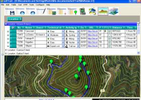
ediTrail1.0 by Aplicaciones Topográficas S.L. |

|
Software Description:
... can be edited over the map with vectorial CAD tools to create, move, split, join, invert trails ... vertices). ediTrail works in desktop mode and into CAD systems, (Autocad/Bricscad/Zwcad). ...
type: Freeware
Download ediTrailcategories: Trail, Route, GPS, gpx, geographical, latitude, longitude, utm, elevation, photo, Track, Way Point, Track Point, hiking, biking, cycling, map, land, terrain, surveying, DTM, D.T.M., digital terrain model, AutoCAD, BricsCAD, CAD, draw, points cloud, contouring, triangulation Add to Download Basket Report virus or spyware |
 [ Zoom screenshot ] |
|
| Software Info | |
|
Best Vista Download periodically updates pricing and software information of ediTrail full version from the publisher,
but some information may be out-of-date. You should confirm all information. Software piracy is theft, using crack, warez passwords, patches, serial numbers, registration codes, key generator, keymaker or keygen for ediTrail license key is illegal and prevent future development of ediTrail. Download links are directly from our mirrors or publisher's website, ediTrail torrent files or shared files from rapidshare, yousendit or megaupload are not allowed! |
|
| Released: | November 07, 2014 |
| Filesize: | 27.05 MB |
| Language: | English, Spanish |
| Platform: | Win2000, Windows XP, Windows 7 x32, Windows 7 x64, Windows 8, WinServer, Windows Vista, Windows Vista x64 |
| Requirements: | Desktop application, MIcrosoft operating systems, 32&64 bits |
| Install | Install and Uninstall |
| Add Your Review or Windows Vista Compatibility Report |
ediTrail- Releases History |
| Software: | ediTrail 1.0 |
| Date Released: | Nov 7, 2014 |
| Status: | Media Only |
| Release Notes: | New version |
Most popular view cad in Other downloads for Vista |
|
TARGET 3001 33.4.0.7 download by Ing Buero FRIEDRICH
... mechanical integration. The software provides a realistic 3D view of the PCB, enabling designers to inspect the ... component placement. This 3D capability extends to mechanical CAD integration, allowing for the seamless incorporation of the ...
type: Demo
View Details
Download
categories: TARGET 3001, download TARGET 3001, TARGET 3001 free download, design PCB, PCB designer, PCB Layout, PCB, CAD, Simulation, designer |
 |
|
EFM CAD File Manager 3.21 download by Etecad
EFM CAD File Manager, developed by Etecad, is a robust ... intuitive solution designed to streamline the management of CAD files within engineering and architectural environments. Tailored specifically ... collaboration across teams. At its core, EFM CAD File Manager excels in organizing and managing a ...
type: Trialware
View Details
Download
categories: design software, EFM CAD File Manager free download, Etecad, AutoCAD, CAD management, file organization, picture viewer, download EFM CAD File Manager, EFM CAD File Manager, file manager, manager, project collaboration, organize, organizer, CAD file organ |
 |
|
Gerbview 10.30 download by Software Companions
... powerful tool stands out in the realm of CAD and CAM applications, offering a comprehensive suite of features that streamline the process of viewing, printing, and converting these file formats. At ...
type: Trialware
View Details
Download
categories: Gerbview, download Gerbview, Gerbview free download, print Gerber image, view plot, convert Gerber, markup, Gerber, modify, adjust |
 |
|
ediTrail 1.0 download by Aplicaciones Topográficas S.L.
... inheritance of data, attributes, etc. Presentation on map: View on map in accordance with the active trail, ... Display/management of photographs: I have created an images viewer so that you can see them easily and ...
type: Freeware
View Details
Download
categories: Trail, Route, GPS, gpx, geographical, latitude, longitude, utm, elevation, photo, Track, Way Point, Track Point, hiking, biking, cycling, map, land, terrain, surveying, DTM, D.T.M., digital terrain model, AutoCAD, BricsCAD, CAD, draw, points cloud, contouring, triangulation |
 |
|
PackMage 3.2.2.83 download by Packmage Technology Co., Limited
... capabilities are particularly noteworthy. PackMage enables users to view their designs in a realistic 3D environment, allowing for a comprehensive examination of the packaging from all angles. This feature not ...
type: Demo
View Details
Download
categories: PackMage, custom boxes, CAD, box, 3D box design, package, package design, design tools, PackMage free download, carton box design, logistics, Packmage Technology, download PackMage, design, packaging software |
|